Tuesday, October 3, 2017

Kayak Bill Camps - Cape Calvert Camp


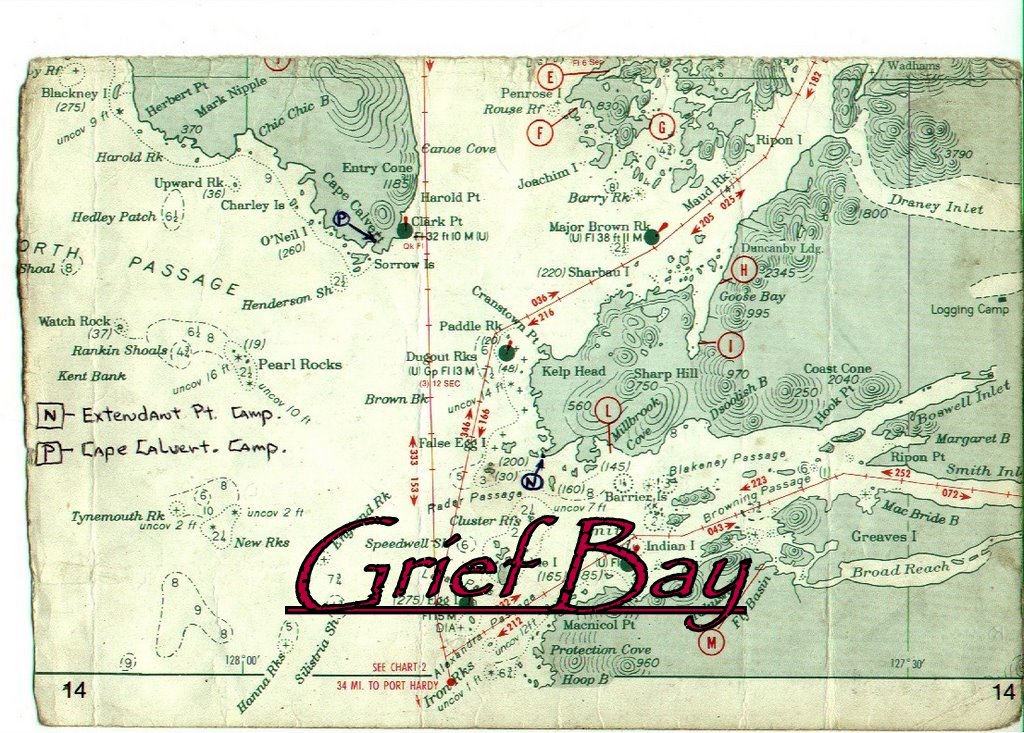
“Cape Calvert Camp” is located in Grief Bay at the southern tip of Calvert Island.  At just under 8 NM northwest of Extended Point it’s an easy paddle provided that conditions on Queen Charlotte Sound are accommodating. 


The bay is protected by the Sorrow Islands that sit approximately 800 meters offshore and block unfriendly seas from almost all directions.  If Extended Point was Maintenance Hell, Calvert Camp was Paradise as most large logs either drifted past Cape Calvert or got caught up on pocket beaches to the west.  The logs that did make it into the bay collected mostly on the rocky west end of Grief Bay leaving the eastern end relatively clean and the forest accessible.  

Monday, October 2, 2017

Kayak Bill Camps - Mustang Bay


Mustang Bay is on the southeast edge of Hunter Island just off Naulau Passage.  “Mustang Bay Camp” is ~26 NM from “Cape Calvert Camp” and ~32 NM from “Extended Point Camp”.  Close to that “25 miles between camps” mark that Bill preferred. 

From Mustang Bay to Swordfish Bay it is just over 12 NM that can be traversed with little exposure.  Naulau Passage is benign in almost all conditions and some southerly exposure would come crossing Kildidt Sound to the Serpent Group then running in the lee to the Kitty Hawk Group.  I suspect Bill stayed put when “conditions” were expected.
 
All that I know about Mustang Bay is this description:


“On tiny island in a group of 3 in mouth of Mustang Bay (Hunter Island).  Have to go for water via kayak.  “Two unintelligle words” of wood, good clamming, nice spot, hard landing @ LW”.

Two clusters of three islets fit the description.  A northern group with the largest island at ~700 meters in length and a more southerly group with the largest at ~170 meters.  They all look like hard landings could be expected under various tide levels and winds.  Good clamming?  Not sure where that would be unless it is on the largest of the 6 islets.


I’m not certain when this camp was in use.  During the last year of his life he didn’t travel to the southern camps and I suspect this camp was more than a bivi camp but probably not a whole lot more. Since choice driftwood for constructing a major camp would not have been plentiful I would be surprised if I learned that there was a full windscreen.  Also, the fact that the island had no water source would be very inconvenient. 

It’s on a part of the coast where my travels don’t take me and searching those islets could be very time consuming and unrewarding.  I doubt that I will ever go have a look but if you have information or are interested in having a look-see please let me know.

I would love to know more about this one as it is a mystery to me.  Have you been there?

Continued..........
Sunday, October 1, 2017

Kayak Bill Camps - Higgins Passage


This is another camp that has evaded me and it was a key stop for Bill.  It was here that he could look up and down Laredo Sound while waiting for the conditions to allow a safe crossing to Aristazabal.  He spent the last three days of June and first 3 days of July 2003 here waiting out a moderate storm on his way to camps on the outer coast of Aristazabal.  He entertained a kayaking visitor on June 28, found a new mussel bed and complained of mosquitoes.  Returning for 5 days in late September he complained again about black flies and mosquitos, commented on the number of wolves in area and a Grouse that he shot at but missed. 

Glenn Lewis encountered a man in Higgins Passage a couple of years back who had run across Bill at this camp and described it as not having a beach and being set back in the forest enough that it wasn’t visible from the water.  That could have been the reason I wasn’t able to find it in 2007 as I was looking for a windscreen.  Maybe he is the visitor Bill met on July 28.  My efforts at locating the camp failed again in late July 2017 but I’m pretty sure I know where it is now.  While lacking an easy access beach other aspects of Higgins Pass Camp make it “Classic Bill” in that it is unlikely that you would ever know it was there or ever stumble upon it.  How it has survived the ravages of the Great Bear Rainforest remains to be seen. 


Approaching Higgins Passage from the west on a clear day is an exercise in patience and confusion.  The western shoreline of the outer BC coastal islands trail off into the Pacific as a complex and confusing mass of broken islets and exposed rock.  Navigation, by chart is difficult and GPS improves the process by only a small margin.  By cheating with GPS, and still getting the maze wrong, I eventually stumbled my way to the island where Kayak Bill Davidson maintained this primary and strategic camp.

Saturday, September 30, 2017

Kayak Bill Camps - Aristazabal


Bill had pushed his camps north beyond Seaforth Channel as far as Wallace Bight but I don’t think that he fancied the reaches and may have found them claustrophobic and leading to nowhere that he wanted to be.  There is the issue of bears, too, which the majority of his camps avoided by location.    In general, his camps seemed strategically located to avoid population and provide stepping stones to increasingly remote locales. 

Aristazabal Island forms the western edge of the Outside Passage at Swindel and Price Islands.  The southern tip of the island is separated from Price by 7.1 NM of Laredo Sound which tapers down to Laredo Channel and just 2 NM south of Shotbolt Point.  It can blow up fast and strong anywhere along the length of the island so most crossings occur in this area with few choosing the longer exposure in Laredo Sound.  In that context it makes sense that Bill would choose the longer crossing supported by camps established on both sides.


Thursday, September 28, 2017

Kayak Bill Camps - Cockle Bay


Bill had been out for nearly four months and was taking his time getting back to Shearwater to resupply.  On October 2, 2003 he experienced a “Perfect traveling day along Swindle Island shore” while paddling from Higgins Pass Camp to Dallas Island nudged on by a light westerly breeze.

Eastbound on Higgins Passage

After two nights on Dallas he did a surprising thing.  A man who considered 25 NM an average day traveled just under 4.5 NM through Moss Passage to the Heiltsuk Cabin located on the eastern shore of Lady Douglas Island in Cockle Bay.  

Saturday, November 7, 2015

Bella Bella 2 Prince Rupert 2015

Image by Dave Resler


McLoughlin Bay to Quinoot Point
July 27 / Day 1
Overcast with showers, Winds calm raising to SW @ 12 knots, Calm to 1’ wind waves, Seas rippled


Launching from the rocky beach adjacent to the ferry dock took me back 10 years to my last visit to McLoughlin Bay and first trip to the BC coast.  Dave and I had been drawn together during the ‘70’s by our love of hang gliding.  I had sold him his first glider and we had shared many thermals, windy launches and LZ’s but Dave’s move to Idaho had separated us geographically and we hadn’t stayed in touch.  Then in 2004 Dave contacted me.  He was back in town and it turned out that we shared an interest in paddling.  He had taken a couple of kayak trips with Larry Longrie and Keith Blumhagen and wanted to share the experience with me.  He had brought me to this very beach in July 2005 and introduced me to the magic of the Wild Coast.

By 2007 we had convinced my co-worker, Greg Polkinghorn, that he should come along with us, which he did,  and he was returning now for his 4th trip.  This was my 7th and Dave’s 9th

Inspired by Washington paddler Chuck Curry’s accomplishment of paddling the outer coast to Sitka, we set the modest goal of paddling the outer BC coastline between Prince Rupert and Victoria.  We would do it in bits and pieces.  Emboldened by the “Outer Coast Guides” published by Glenn Lewis with the help of Harriet Rueggeberg, Reale Emonds, Karina Younk, Geoff Mumford and Ursula Vaira we felt the time was right for us to take a sizable bite out of the elephant and paddle the outer coast of Athlone, Price, Aristazabal, Estevan Group, Banks, Porcher and Stephens Island.  I liked the fact that we were starting this trip where my BC coastal explorations had originally begun.

We shared the beach with two Canadians who were bound for Port Hardy in a double.  Their plans called for spending the night, close to Shearwater, on Rainbow Island so that they could start their trip after an evening of pizza and beer.  I suspect that their double, like a good horse, knew its way back to the barn and could deliver the cowboys safely to their camp.  Sounded like a decent idea to me but we were off to the Heiltsuk cabin on Quinoot Point for the first leg of our journey.  


McLoughlin Bay to Quinoot Point Chart

Wednesday, November 13, 2013

Port Hardy 2 Coal Harbour 2013

Image by Dave Resler

Dave and I planned to paddle from Port Hardy around the north end of Vancouver Island…..sort of.  I say sort of because normally there are months of detailed planning that precedes these trips but both of us were so busy with family and work that planning was crammed into very short, individual and last-minute time slots.  Dave, the fastidious planner, would normally have three routes carefully worked out with different timelines for each.  We would pick one as conditions presented themselves and stick with it.  I had learned a lot from him and incorporated his style into my solo trip plan in 2012.  During that trip, however, I found that I was very comfortable going off-plan and switching from one to another as conditions and opportunities presented themselves.

Our basic plan was to paddle up Goletas Channel towards Cape Scott, the far end of Vancouver Island, and down the west coast to Quatsino Sound ending in Coal Harbour.  Conditions and whim would determine our exact path to Cape Scott and our daily distance, overall.  We weren’t pressed for time as we had three weeks. We could finish early or afford to get pinned for days somewhere with no way to get off the beach.

Ultimately, tides, winds and sea state would dictate progress and we could choose to cross Goletas Channel to the God’s Pocket complex, Nigei Island and Hope Island areas to just poke around and hide from high winds and weather or just hang out.  We could also choose to benefit from the favorable morning ebbs that should push us up the channel and on our way.  Current in Goletas Channel runs up to 3 knots with intersecting currents running to 5 knots providing an environment where rips and ragged water can be generated.  Throw a west wind against the ebb and progress could become arduous and busy. 


Between Vancouver and Hope Islands Goletas Channel escapes into the open Pacific where Nahwitti Bar rises up from the depths to confound and anger the current, winds and swell.  Vessels of all size consider conditions on the bar and it can go off.