
Image by Dave Resler
McLoughlin Bay to Quinoot Point
July 27 / Day 1
Overcast with showers, Winds calm
raising to SW @ 12 knots, Calm to 1’ wind waves, Seas rippled
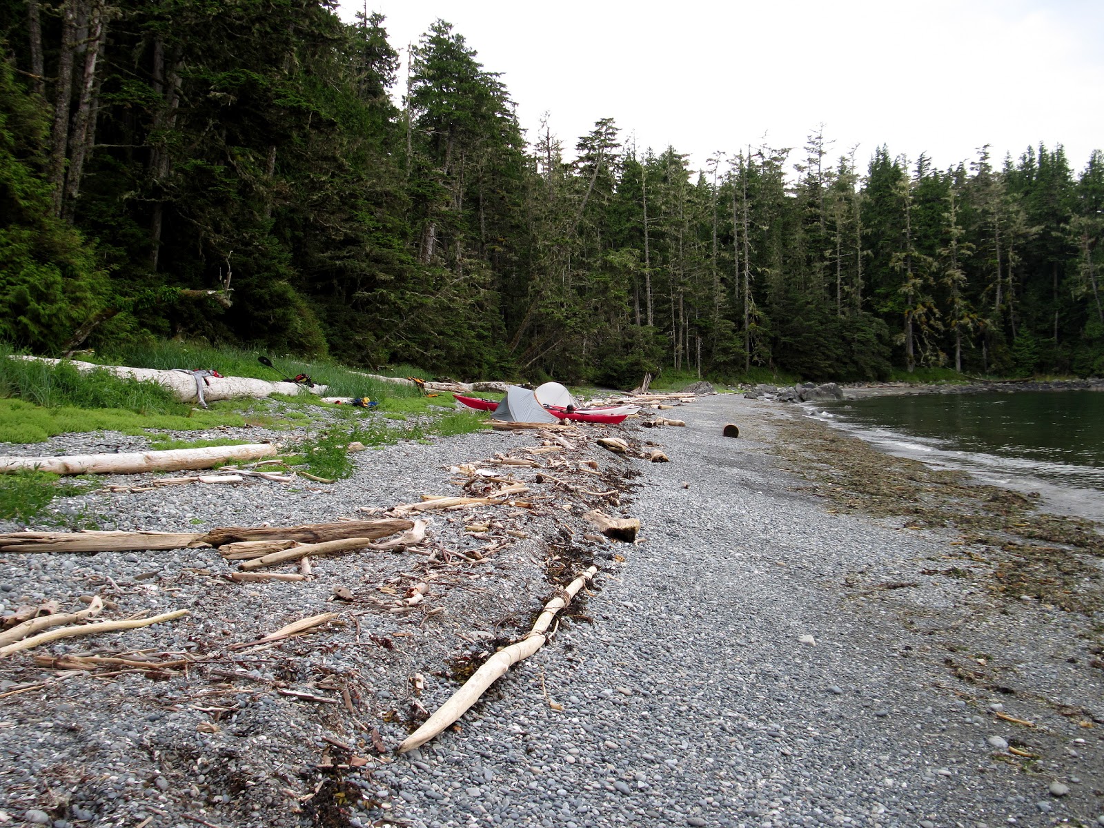
Launching from the rocky beach adjacent to the ferry dock took me back 10 years to my last visit to McLoughlin Bay and first trip to the BC coast. Dave and I had been drawn together during the ‘70’s by our love of hang gliding. I had sold him his first glider and we had shared many thermals, windy launches and LZ’s but Dave’s move to Idaho had separated us geographically and we hadn’t stayed in touch. Then in 2004 Dave contacted me. He was back in town and it turned out that we shared an interest in paddling. He had taken a couple of kayak trips with Larry Longrie and Keith Blumhagen and wanted to share the experience with me. He had brought me to this very beach in July 2005 and introduced me to the magic of the Wild Coast.
By 2007 we had
convinced my co-worker, Greg Polkinghorn, that he should come along with us,
which he did, and he was returning now for his 4th trip.
This was my 7th and Dave’s 9th.
Inspired by
Washington paddler Chuck Curry’s accomplishment of paddling the outer coast to
Sitka, we set the modest goal of paddling the outer BC coastline between Prince
Rupert and Victoria. We would do it in bits and pieces. Emboldened
by the “Outer Coast Guides” published by Glenn Lewis with the help of Harriet
Rueggeberg, Reale Emonds, Karina Younk, Geoff Mumford and Ursula Vaira we felt
the time was right for us to take a sizable bite out of the elephant and paddle
the outer coast of Athlone, Price, Aristazabal, Estevan Group, Banks, Porcher
and Stephens Island. I liked the fact that we were starting this trip
where my BC coastal explorations had originally begun.
We shared the beach
with two Canadians who were bound for Port Hardy in a double. Their plans
called for spending the night, close to Shearwater, on Rainbow Island so that
they could start their trip after an evening of pizza and beer. I suspect
that their double, like a good horse, knew its way back to the barn and could
deliver the cowboys safely to their camp. Sounded like a decent idea to
me but we were off to the Heiltsuk cabin on Quinoot Point for the first leg of
our journey.

McLoughlin Bay to Quinoot
Point Chart
Temperature was a comfy 60-ish degrees combined with a nice SW
breeze and a waning ebb pulled us past Bella Bella into Seaforth Channel.
There the current switched to flood and progress slowed to a semi-slog.
Then the rain began but it didn’t dampen our spirits and soon enough we entered
Joassa Channel for the final push to Quinoot Point.

Approaching
Bella Bella
We
were passed by a few large pleasure boats in Rait Narrows and found many more
at anchor in the inlet that punches east into Horsfall Island. The breeze
continued to build and the final 2 NM to the cabin was directly into a 12 knot
breeze. Those miles didn’t exactly fly by. Greg had separated from
us to fish a bit but was uninspired and losing ground in the breeze. He
caught up and joined us shortly before we pulled into the protected cove at the
point.

Rain in Seaforth Channel
These
First Nations cabins are wonderful coastal sanctuaries but are so often in
disappointing condition. Owing to the nature of the garbage that is often
left by previous visitors it is clear that it isn’t kayakers who aren’t
cleaning up after themselves. The vegetation surrounding the cabin was
badly overgrown and the steps leading up to the door in poor shape.
Inside were the remnants of a religious retreat held for local
youth complete with a Spiderman blanket, small socks and the remains of at least
three New Testaments that had had been ripped up and tossed about. The
“kitchen counter” was piled high with three damaged two-burner camp stoves,
broken radios, a CD player and collection of discs by some singer I had never
heard of. Greg took one look around, pronounced a state of emergency and
announced that in spite of the rain he was going to spend the night in his
tent. Dave and I looked around for signs that Joey’s spawn (remember
Joey?) still owned the cabin but found nothing. We figured that he/she
would show up during the night to kick ass and take names.

Quinoot Cabin
During
the night it rained and blew hard. Joey never showed. It seems that
even he had given up on the cabin or, his penance served, moved on to enjoy
life in a form more to his suiting than that of a rodent.

Joey Walks-with-White-feet
2007
14.5 NM
Quinoot Point to Cape Mark (CM1)
July 28 / Day 2
Rain, SW at 15 knots / Swell 1
meter, wind waves to 3 feet, Seas moderate
It rained
hard off and on all night and I wondered how Greg was faring but he showed up
at the appointed hour claiming that he had stayed warm and dry in his new
tent. After our customary breakfast of instant oatmeal and Starbucks Via
we cleaned up the cabin as best we could, carried our boats down to the
guesstimated tide height of departure and set about loading them up. This
early in the trip we hadn’t eaten through much food so fitting it all in still
required discipline. It usually takes about a week before undisciplined
boat packing is successful. Packing your boat in the rain, at any point
in a trip, is such a treat.
Quinoot’s
“Back Door” opens just a crack though islets and inter-tidal zones to allow
entry into the NE fork of Thompson Bay. Thompson separates Princess Alice
and Athlone Islands from Potts and Stryker. The north end of the bay
forks at Cree Point which is the southernmost tip of Dufferin Island. The
south end of the bay opens at 183 degrees and if you paddled at that heading
your first landfall would be French Polynesia. Needless to say
southerlies aren’t what you hope for but if the back door isn’t open you have
to paddle all the way around Potts Island, requiring an additional 4 NM of
cross-condition paddling. This was my 5th trip through
Thompson Bay and I had learned that it is never a “gimmee”.

Quinoot Point to Cape Mark
Chart
“I’ll take the Back Door,
please.”
We hadn’t gone 200 meters before
gel-coat-eating-barnacle-covered-rocks postponed our exit. Turned out
that the tide was too low and the door wasn’t yet open. Dave and I sat
patiently in our boats waiting for the rising tide to fill the passage while
Greg, beating his plastic Tempest like a Government Mule, got out and drug it
across the barrier. It sounded like a road grader on concrete but he was
free on the other side and back in his boat waiting for us. Dave and I
waited another 10 minutes before stepping into the shallow water and genteelly
floating our boats to the other side. Dave and I are not savages.
Greg? Clearly, “the man ain’t got no culture”.
Crossing the western fork of Thompson Bay to the protection of
Waskesui Passage was raggedy but fun and gave us a taste of what was to
come. We put our heads down and ran for a little over an hour across the
SW end of Athlone Island in the open and beam seas to the protection of the
north-south channel that separates Wurtele Island.
Our intended campsite was AT2 in Yaaklele Lagoon. It was the
same distance downwind as the Cape Mark site was upwind but Cape Mark promised
tent sites above the spring tide which counts for a lot on the coast so we
clawed our way upwind to Cape Mark. Entering the cove from the north put
us on the wrong side of a sand bar so Greg did his
uncultured-plastic-boat-thing and drug the mule over the shallows while Dave
and I paddled around to the south entry and beached just below camp.
Greg expressed a desire to go fishing. The west coast of
Athlone was an area that had been posting glowing catch reports and he was
dying to fish it. He requested permission to wet his line. I
couldn’t imagine trying to do anything other than paddle and attempt to stay
upright in those conditions so Dave agreed to go along and watch his
back. I stayed at camp and monitored them on VHF.

Pounding Rain at Cape Mark
Image by Dave Resler
The rain was pounding loudly on the MSR Parawing making it sound
like I was surrounded by four microwave ovens full of popping corn. Dave
and Greg were having trouble responding to my queries which I, correctly, took
as meaning that they were too busy to talk. I hoped I didn’t have to go
look for them. Eventually Dave reported back that it was too rough
to fish (duh!) and they were heading back in. When they returned to camp
Dave described difficult paddling conditions exiting the south channel and more
difficult conditions coming back in. Not a good day to fish from a kayak.
Rainy (popcorn) night at Cape Mark
9.4 NM
Cape Mark (CM1) to Price Island (P1)
July 29 / Day 3
Overcast and fog then clearing / Light winds / Swell 1 meter with
wind waves to 1 foot, Seas rippled
I awoke at 4:30 AM to find Greg out walking the beach. He
announced that we weren’t going anywhere for a while as there was no water in
sight. No kidding! I had heard that this wasn’t a low-tide kind of
site but wasn’t expecting to look out and see the surface of the Moon.
The tide was going to drop for another 2 hours to .7 meters and all we could
see was rock and gravel. No point in waking up Dave so we made coffee and
waited.
We started the boat-loading routine around 6:00 AM. The
retreating water was well over 100 meters away and each of us had over 100
pounds plus boats to carry requiring 3 – 4 trips each. I took comfort
knowing that we had planned the trip to utilize the morning floods to push us
on our way and this discomfort was a necessary evil.

Cape Mark to P3 Chart
We launched at 8:00 AM and set off, in fog, across Milbanke Sound
on a heading of 310 degrees towards Day Passage at the southern tip of Price
Island. I was rewarded the task of leading since I am able to paddle
while keeping my eyes glued to a deck compass without puking. God help me
if I get bored and want to look around. I get dizzy and might fall
over. I only had to fly under the hood for about an hour before the fog
started lifting and Aristazabal came into view. We had another 2 hours to
go before we could close out our first major crossing but I could look around
and enjoy the view without hurling.

Foggy Crossing Milbanke Sound
Greg streaked ahead to fish the edge of a shelf that runs along
the eastern shore of the island and met us, sans fish, at the entrance to Day
Passage. We split up again near the site marked as P3 in Glenn's
Guide. I wanted to take a serious look at it. Dave and Greg paddled
ahead to our rendezvous point on the west shore of the island.
P3 is a campsite that needs to exist. Being at the southern
tip of Price (N52 17.128 W128 41.141) it has strategic value for any
paddlers crossing Milbanke Sound. Unfortunately, it has some challenges
now. While there is a nice clearing that would accommodate upland tent
sites comings and goings are best made at tide levels exceeding 4 meters.
I would guess 4.5 meters would be OK. Lower tides bring a paddler to a
boulder-choked beach that might not be acceptable for a casual paddler. I
would have to want it really badly to land and leave from that site.
Maybe some serious work creating canoe runs at low tides would make this site
go. Call me casual.
I met up with Dave and Greg at the west end of Day Passage.
It opens to a gorgeous coastline sheltered by rocks and islets. Very
pretty. Nice paddling. We knew that Glenn Lewis was out here
on a solo mission with the intention of establishing P3 and improving
other Price Island campsites so I made several attempts to contact him on the
VHF. I had no luck and was really surprised when he casually showed up in
the middle of our snack break. It’s a big and convoluted coastline and
solo paddlers are easy to miss yet there he was.
He reported that he had spent a very rainy night at P1 (N52
23.206 W128 45.265). I gave him my report on P3 and he said that he
needed to go see it for himself and that maybe he would paddle back to P1 and
join us for the night. We headed north while Glenn paddled off to the
south.

Price Island Chart
We decided to have lunch at P2 (N52 19.192 W128 43.503)
which is described as a “protected cove” in Glenn's Guide. I led us in
through a conglomeration of boomers, reefs and floating logs to the adjacent,
but wrong, cove. It was an exciting ride with a landing on a somewhat
steep boulder “beach”. Not realizing that I had missed the cove by ~100
meters I figured that if it was good enough to be called a protected cove and
campsite by the Outer Coast Crew it was good enough for us to have lunch
at. It didn’t occur to me that the cove didn’t match the benign
description in Glenn's Guide and figured that I just needed to toughen up if I
was going to hang with the Nanaimo Crew. I had paddled a bit with them
and they didn’t strike me as folks who were bent on seeking the sort of rush
that I experienced picking my way in. Honestly, I would have paddled less
aggressively and chosen a much more conservative line if I had known that I was
going into a different place.
After lunch we traveled another 5 NM up-island to P1, a lovely
protected sand beach choked with drift wood that we came to name “Careless
Cove”. Examining the high tide line it was clear that there wasn’t going
to be room to camp below the logs so we looked for a clearing in the forest
above. No luck at all as the upland was disappointingly thick.
Where the hell had Glenn camped? We pulled our boats up onto some logs
above the anticipated evening high tide and I tied them securely to a log 20
feet closer to the forest.

P1 aka Careless Cove
We found Glenn’s campsite a bit to the south of the beach up under
a couple of Alders. He had cleared some of the lower limbs to allow
access and leveled a nice tent site. He had also done some serious
drainage work that had been prompted by the heavy rains the day before.
Greg was inspired by those efforts and cleared a space under another Alder that
accepted his single person tent. He created channels to divert the water
coming out of the forest and lined them with rocks. Some impressive
engineering on par with the Roman aqueducts……….sort of…….I was impressed,
anyway.

Chez Dave
We had a warm, sunny afternoon to work with and spread our gear
all over the beach to dry. Dinner was a treat prepared by Chez
Dave. Full belly and dry gear is so nice.

Careless Cove Sunset
It was a quiet windless evening with a wonderful sunset.
19 NM
Price Island (P1) to Weeteeam Bay
(A6)
July 30 / Day 4
Clear, Light winds to NW @ 10 knots
/ Swell 1 meter with 1 foot wind waves, Seas rippled

Price Island to Aristazabal
Island Chart
We faced another 9 NM crossing to the south tip of Aristazabal and
intended to launch at ~7:00 AM (low slack). We were up at 5:00 AM, had
breakfast and started carrying our gear 75 meters over the rocks from our
campsite to the adjacent cove where we had secured our boats. Dropping
the first load I looked 100 meters up the beach and saw that our boats were no
longer on top of the logs. They were still there but Dave’s Grand
Illusion was against the logs pointing north, Greg’s Tempest was against the
logs pointing south and my Tempest was between them, sideways with the stern up
on a large rock! It was obvious that we had miscalculated the evening's
high tide.
I went to investigate and realized that I had neglected to
put my cockpit cover on. The cockpit was full of water and wet
sand. I was relieved to find my paddle halves and chart case still in the
cockpit and poking through the wet concrete. My helmet was packed with
wet sand and weighed as much as a bowling ball. I hoped that my hull
wasn’t cracked. Greg’s boat was full of water and sand (no cockpit cover)
and tipped on its side. His chart case was hanging from the deck lines
like a water balloon full of tan confetti. He had most of Dave’s charts
and they had spent some time in the washing machine……as did Greg’s
GPS……... Dave’s boat was fine with the cockpit cover in place.
Nothing missing. Cockpit clean.
I had tied the boats together and secured them to another log with
my tow rope. My knot had done its job but how did we miss this? Together
we had examined the previous night’s high tide line and thought we had taken
the increase of 1/10 meter well into account. We had pulled the
boats up onto the logs with the sterns on a log that was at least 1/3 buried in
sand and above where we thought the water could possibly reach. Even if
it did touch that log it couldn’t float it……….Yet it had. The tide had
somehow moved it out of the way, pulled our boats off of the other logs above
the tide line and sent them on a yahoo-ride. This was with totally calm
seas on a protected beach. Pretty sobering.
Dave had lost seven charts costing $140 USD. We gently
emptied the water out of the case, pressed the confetti flat and strapped it
back to the deck intent on salvaging some of the larger pieces. Greg’s
GPS would no longer acquire satellites so it was toast. The good news was
that I had brought my back-up GPS which worked fine but would no longer
download data to Map Source or Home Port. I gave it to Greg. My
hull was fine and all my gear intact but cleaning the wet sand out of the
cockpit, helmet, etc. took a while and continues to this day.
Eventually we were ready to launch and it was then that Greg
realized that his graphite Werner was MIA. He had propped it between some
logs near the bows of our boats and hung laundry on it to dry. It was
gone. We spent about 45 minutes combing Careless Cove for that paddle
before giving up, tucking our tails between our legs and accepting that the
$800+ lesson we had just experienced was a cheap slap in the face that we had
well deserved. While Greg’s spare paddle could best be described as a
heavy, blunt instrument Dave’s Ikelos filled in nicely.
We set off across Laredo Sound for Kayak Bills Camp (A8) near the
south end of Aristazabal Island. Bill referred to this as Camp I on his
charts. It was another 9 NM crossing, but this time, without fog.
Just a 3 hour walk in the park. Approaching Aristazabal Greg asked if he
could separate from us and fish, staying in touch by VHF. We agreed and Dave
and I set out for the A8 coordinates provided by Glenn's Guide.

Kayak Bill's Beach Camp I
We poked around on a beautiful section of seldom-seen coastline
before landing at Bill’s Beach and found it choked with large drift logs.
The signature windscreen was easy to spot above the head high vegetation that
filled the forest floor and I had to bushwhack back to the camp. I found
a partially collapsed windscreen and all of the classic elements that
characterized Bill’s camps. This camp had benefited from a wooden center
ridge tarp support instead of the usual rope.

Camp I Windscreen
Greg
met us as we were coming out and we continued together through a cluster of
rocks and islets that mark the south end of the island. What a wonderful
place with a very wild look and feel. Gorgeous rocks and brilliant blue
water. Like the south end of Price, this place begs to be explored.

Kayak Bill's Beach Camp III
Camp III is marked with a buoy and is fairly well preserved.
All of the classic elements are on display. I found it most remarkable
that his wood supply was perfectly dry after all of these years. He had
last been in this camp on September 27, 2003, a little over 2 months before his
death in December. That meant that his perfectly split and precisely cut
firewood had been sitting there for nearly 12 years.

Kayak Bill's Firewood Stash
After
dinner we gathered wood from the beach and built a fire. As a tribute, of
sorts, I took a single stick from Bill’s supply and we split it three
ways. Each of us placed our piece onto the fire with a “Thanks” to Billy
Davidson:
Dave: “Thanks
for getting us out here”
Greg: “Thanks
for the adventure”
Me: “Thanks
for the inspiration"
Each
piece burst into flames and burnt with a strong cedar scent.
14.3 NM
Weeteeam Bay (A6) to Islet 145 (A4)
July 31 / Day 5
Overcast with light rain , NW @ 10
knots, Swell 1 meter with 1 foot chop, Seas rippled
Due to
the short route we had planned for this day we chose to sleep late, ate a very
leisurely breakfast and spent a relaxing hour or so filtering water. Bill
had a water hole above the east end of the beach that he had spanned with a
wooden plank. The plank is no longer trustworthy and the water hole has
silted up to the point that we couldn’t skim anything worthwhile out of it but
it seeped out onto the beach where we dug a hole in the sand for it to collect
and skim.
We loaded
up our Dromedary Bags and launched at 10:30, midway into the flood cycle.

Filtering Brown Water
It rained off and on but never hard and the short trip from Weeteeam
Bay to Clifford Bay was uneventful but we would have never looked for a
campsite (A4) on the north end of Islet 145 if it hadn’t been noted in the
Glenn's Guide. We arrived about 45 minutes before high slack of 4.8
meters and there wasn’t much evidence that a beach existed. We sat in our
boats and looked around the cove for something that we felt we must be missing
but seeing no other options we landed.

Aristazabal South Chart
The forest came right down to a narrow flat grassy ledge that
offered space for two tents. Behind that ledge the forest opened nicely
to a soft mossy space surrounded by very large CMT’s. An animal trail
pressed into the moss led across the clearing from a tunnel under one fallen
giant to a cozy den under another. I set my tent up in the clearing and
wondered if I would be visited during the night.

Grassy Ledge Camp A4
Greg went fishing south of Benney Islets. Surprisingly, he
came back empty handed.
A4 is a very nice campsite.
9 NM
Islet 145 (A4) to Rennison Island
(R1)
August 1 / Day 6
Overcast then clearing in the
afternoon, NW @ 12-14 knots, Swell 1 meter with 2 foot chop, Seas rippled
We planned a 21+NM day and wanted to have as
much current in our favor as possible so we launched at 7:46 AM. That was
about an hour before low slack. The drawback to A4 is that the little bay
that fronts it is quite shallow for some distance so when we packed up our wet
gear and started carrying it to the water’s edge it was close to a 100 meter
slog. By the time we actually launched the water had retreated another
100 mucky meters.

Aristazabal South Chart
Once into open water we picked up some current and traveled for
about an hour at near to 4 knots without trying. Our lunch stop came
early at Kettle Inlet (A1) and after 40 minutes we were back on the
water. Our plan was to paddle direct across Beauchemin Channel from
Wriglesworth Island to the large island in the Anderson Group and make a
decision there whether to stay or push on to Rennison. If the weather
called for rain we would stay at Anderson’s shelter. Wherever we stayed
we would start our crossing to Dewdney Island in the Estevan Group from
Rennison so R1 was the better choice. No rain in the forecast so we set
our sights on Rennison.

Dave off Aristazabal
The fog set in while crossing Beauchemin Channel and Anderson was
lost from view so we went back under the hood on a 310 degree course. We
passed through a few enjoyable sections of the channel where current was
running and producing loud standing waves. Once the fog cleared we rafted
up for a fuel break and while sitting there doing nothing I noticed that my GPS
indicated that we were drifting at 2.8 knots in the desired direction.
The day turned into a cloudless 55 degree sparkler with a
favorable push and we achieved up to 5.8 knots without working at it.
Rather than race with it we adopted a very relaxed cadence and took the
ride. A Humpback surfaced off to our left and kept us company for a
while. The NW wind carried his breath and stunk the place up.
About ½ NM north of Tuzo Islets we crossed a line of floating
debris and hit a wall. We didn’t realize it, though, as nobody had their
GPS on. The wind picked up which added texture to the water and made it
feel like we were still flying. Greg was far out ahead as usual while
Dave and I paddled together with the mistaken idea that we were mainlining the
secret truth of the universe. Sky Bros, once again.

Aristazabal North Chart
At some point it occurred to me that I had been looking at the
same rocky point for too long so I turned on my GPS. While it was booting
up Dave said that we were “just screaming along”. Once it booted up and
told the truth that we were nearly standing still I broke the news to Dave that
we were below 1 knot. I headed towards shore seeking shallow water,
increased friction for the opposing current and less resistance. Dave
stayed out in the channel with Greg and slogged on. The NW wind and
current wasn’t allowing for much progress towards shore but little by little I
gained bits and pieces until I was close enough to shore that the island
blocked some of the wind and the shallower water reduced the current. The
ability to make 2 knots was a major victory and once back to 3 knots I watched
Dave and Greg drop behind out in the main channel.
2.5 NM after hitting that wall I pulled into a shallow protected
cove to wait for Dave and Greg. The cove was covered with black rocks
that heated the cold water to a very comfortable bath-like temperature. I
laid in the warm water until Dave arrived. We figured that the flood flowing
north up Laredo Channel must wrap around Aristazabal and collide with the flood
entering Beauchemin Channel from the south. Whatever, it was a grunt.
We stopped at a cove about ½ NM shy of our intended campsite (R1)
to check out a stream. It’s a good one and surprisingly strong for one
located on an island the size of Rennison. Additionally, the uplands are
open enough that it wouldn’t take a lot of clearing to create tent sites.
It could be a very nice place to camp.

Greg & Jon in Caamano
Sound
Image by Dave Resler
We continued on to R1 and judged that the evening’s high tide of
5.4 meters might not allow room for beach camping. Retreating back to the
beach just east of R1 we found room for a couple of tents in the uplands on the
point that separates the two beaches and quickly cleared enough Salal to
accommodate a few more.

Rennison Beach
A small cabin cruiser was anchored just off our beach and the
pilot came ashore with his dog to offer us some salmon. Seems that he had
been catching way more than he could eat or keep. We were appreciative
but too beat from paddling and clearing tent sites to cook a real meal so we
thanked him and turned him down. This clearly upset his dog who went off
on us. Jeez! Sorry! I think that dog was a little high strung
to begin with. We boiled water, poured it into a bag, waited 8 minutes,
stirred it, ate it and crashed.

Rennison Tent Site
While
the rocky access to the uplands is a little ragged the spaces we cleared offer
very nice camping and a good night’s sleep surrounded by CMT’s.
21.4NM
Rennison to Oswald Bay
August 2 / Day 7
Overcast turning to rain / Winds
light NW, Seas calm
Our day started with another 9NM crossing.
This time it was Caamano Sound from Rennison to Dewdney. The morning was
definitely right for us as winds were calm and seas flat. The guy who had
offered us Salmon the night before was off shore fishing and Greg approached
and asked him how the fishing was. He responded that it was “stupid good”.
Greg gnashed his teeth hearing that and would have put off the crossing for the
opportunity to wet his line. The fisherman’s dog smiled knowingly and
growled.

Rennison to Dewdney Chart
The
crossing to Dewdney took just over three hours. We rafted up and refueled
for the final push to Oswald Bay.
Another
three hours found us off the rocky shoreline south of Le Jeume Point where Greg
wanted to fish. I was eager to reach the campsite in Oswald Bay and get
out of the boat. Dave stuck with Greg for a while and I continued on.
Greg provided.

Greg Provides
Image by Dave Resler
It
took me another hour to find the campsite that was only 2.5 NM away.
Oswald Bay confused me and in spite of using my GPS I took some wrong turns and
ended up on the wrong side of shallows that required reversing my track.
The beach is a decent cobble / gravel mix with open areas for tents in the
uplands.
Dave
radioed me asking for directions and, he too, took some wrong turns. Once
he landed he told of a very large Ling Cod that Greg had landed. We were
going to eat well.

Oswald Bay
Radio reception with Greg was poor and we finally made out that he
was coming in. He had a GPS so the campsite should be easy to find.
Turned out he paddled right past the beach without seeing us, got confused,
turned around and started blowing his whistle. We signaled back and he
eventually found his way in. While we made it an adventure to find this
campsite it is really straight forward. Just some group-hysteria, I
guess. The bay does dry extensively at low tide and that creates some
pitfalls. Very good upland camping, though.

Oswald Bay to Wolf Meadow
August 3 / Day 8
Rain, W to 15 knots, Swells 1 meter
with 3 foot chop, Seas moderate
When planning this trip we had viewed the 2 NM crossing of Otter
Passage from Trutch to the south end of Banks as a crux move. Nautical
charts indicate max currents run at up to 6 knots through the Block Islands
with a slack lasting only 11 minutes. The passage is littered with rocks,
islets and shallows with contrasting depths of up to 400 feet. It has all
the makings for complex, technical water and Google Earth shows some wave
patterns that support that train of thought. We definitely wanted to
avoid a strong ebb against a west wind and with our low slack occurring at
10:11 AM we wanted to use our slack window wisely. The wind usually
doesn’t start building before 11:00 AM but still it was a crossing we were
normally more comfortable doing earlier than 10:00 AM.
Our campsite in Oswald Bay was 8 NM south of the passage which
meant that we had about 2.5 hours of paddling to do before starting the
crossing. Dave suggested that we make a longer crossing west of the
congestion of the passage and take advantage of deeper water. That would
mean breaking away from Trutch earlier but would make the timing less crucial.

Estevan to Banks Chart
Shortly after 6:00 AM we left the beach and headed NW up the
island. We never got much above 2.5 knots as we were paddling against the
ebb current and as we neared the end of Nichol Island and the opening of
Langley Passage our speed dropped even more as the contrary current
increased. The outflow from Langley Passage pushed us a bit further
offshore and the surface texture showed the results of swell bent and reflected
by current.
At 9:00 AM and a little over 1 NM south of our originally planned
crossing point we struck off across 5.7 NM of open water for a large rock face
on Banks Island midway between Calamity Bay and Terror Point. For 20
minutes the Otter Passage ebb pushed us strongly off course to the west but
released us after 1 NM. For the next 1.5 hours we encountered occasional
mild rips marking conflicting currents but little else. During the
crossing the west wind had begun to build to 15 knots contesting our
progress. Rain picked up and battered our faces and eyes. A shelf
that runs for over 1 NM off the south end of Banks reduces the depth to less
than 100 feet and creates some dynamics that made achieving Banks a little more
work than expected. Swell and wind waves jacked, bent, crossed and
reflected combined with unexpected current to make for an enormous playground
but offered no easy opportunity for progress. Making it past the rock
face we had been looking at for the last 3 hours took some time.
We ground along between <1 knot to <2 knots for over an
hour, at times paddling hard but making no headway at all. We were 7
hours into the day’s objective and just a little short of going
backwards. We were getting banged around, rain was increasing and
conditions were deteriorating. We had a ways to go.
Grinding along at 2 knots we turned the corner near Terror Point
and our speed picked up a bit. So did the texture of the sea as swell and
wind waves reflected off the steep face of the point and reached well
overhead. Lots of fun but we were tired and ready to rest. Rounding
the point we pulled hard for the north entrance of the shallow channel between
Banks Island and the two islands that create Terror Point.
The shell beach that provides camping in that channel was easily
located and we landed to take a break. It’s a nice beach but lacks
shelter from any sort of wind real wind. It is backed by a rocky bluff
that limits access to the uplands. Looks nice but really didn't seem so
friendly. Greg climbed the bluff and disappeared into the thick forest
for 15 minutes. He finds a way to bushwhack through the most difficult
conditions but upon his return said that there was no way to clear tent sites
or haul our boats up the bluff.
I saw a spot across the channel that looked promising and Greg
struck off in his boat to explore a small cove to the south. I found that
the gravel beach was topped with large black boulders that would limit comings
and goings at tide levels above 4.8 meters, however, there was room above the
beach beneath large trees that would allow two small tents. The site
could be improved and definitely offers shelter from the elements that the
shell beach does not. Greg found the forest behind the cove to the south
small-ish and in need of improvements in order to accommodate any upland
camping at all. Maybe better than the shell beach for high tides or
weather.
We all wanted to end our day but Terror Point didn’t look like the
answer we wanted to hear so we continued on in the rain for another 5.3 NM
before turning north and entering the inlet where were expected to find the
“Grief Point” campsite described in the Glenn's Guide.
While it’s a relief to be able to relax in the sheltered water of
an inlet I find that it is also a bit of a let-down. Active paddling
switches to relaxed paddling and the water feels sticky and slow.
I see and feel the rain that was overshadowed by the demands of
technical paddling only moments before. Hard-worked muscles start to cool
and cramp up. Fun VS Un-fun. Time to find a campsite.
My GPS started acting up just before the batteries died and I
interpreted its last gasp incorrectly and led us into the wrong cove.
Dave looked around, knew that it wasn’t right and continued on. Greg and
I landed and quickly realized that there would be no camping at this site with
the next high tide.
Meanwhile, Dave had continued on in search of something better and
eventually radioed that he had found a place that looked reasonable. We
followed his instructions further up the narrowing inlet that ended with a
strong stream flowing from a tidal lagoon. A wide canoe run sloped up
from the water to a forest-backed grassy meadow.

Canoe Run Wolf Meadow
A small stream flowed out of the meadow and at its mouth was a
stone fish trap. We were clearly in the right place.

Fish Trap Wolf Meadow
Access to the uplands was visible beneath heavy tree limbs and we
found ample space with minimal improvements needed to accommodate our
tents. The remains of some sort of structure poked out from the overgrown
forest floor. We pulled our boats up into the edge of the forest and tied
them securely above the inter-tidal grasses.
Investigating the meadow we found that it extended about 60 meters
back from the shore and was about 30 meters wide. The tall grass was
beaten down except for sections along the edge where some of it still
stood. There were deposits of wolf poop every square meter over the
entire meadow. Here and there small game trails entered the forest.
We wondered if the wolf pack was watching us and thought us cheeky for setting
up camp at a site that clearly belonged to them.
They didn’t visit us during the night or bless us with their song.
Wolf Meadow to Kelp Point
August 4 / Day 9
Though it rained all night we were sheltered by large trees and stayed dry
inside our tents We ignored the morning alarm and stayed in bed late as low
slack was at 10:55 AM giving us no reason to get on the water early.
The
outside of Banks Island is littered with all sorts of confidence-inspiring
happy place names. We had already enjoyed Calamity Bay and Terror Point.
The route from Wolf Meadow would take us past Grief Point, Foul Bay, Junk
Ledge and Wreck Islands not to mention the site of the Banks Island Gold Mine
that had been shut down for polluting the environment. Our concerns with
pollution from tailings forced us to carry water from well before Foul Bay to
well past. You have to wonder why someone named these places after bad
experiences.

Wolf Meadow to Crap Camp Chart
Once on the water I was in to what may be my least favorite day of
paddling ever. It was followed by what was certainly my least favorite
night. The paddle up island was just a grey wet slog. Low grey
clouds, grey rain, grey water, grey wind. No reflections to brighten
things up. A very tough day paddling in rain and 15 knot west winds.
Awkward wind direction, adverse currents, bent and reflected waves.
Staying upright took concentration. Staying warm was more
difficult. No place to land, let alone camp.
After three hours we pulled into the Wreck Islands campsite
described in the Glenn's Guide as “the sort of place one would seldom choose as
a goal”. That pretty well summed it up for us and we pushed on in the
wind and rain for what the Guide describes as “by far the best site in this
area”. It is 1.5 NM south of Kelp Point and sets back in a narrow
tapering bay. We would have never found it without the guide and we were
desperate to get off the water. It looked welcoming…….at first
It was 4:00PM and we had been having a “wonderful time” for the
past 5 hours. High slack was an hour away and that would show us how much
beach we had to work with. The MSR Parawing was put up for shelter from
the rain and we started looking around to see what areas might be large enough
to fit out tents. The beach was packed with large drift logs that
wouldn’t budge and beneath all of that heavy wood rivulets of water ran down
towards the sea. If you made any sort of a depression in the sand it
quickly filled with water. We didn’t like the place at all but we had to
take it.

Me to Dave and Greg:
"Dudes! Are we screwed?"
Greg: “I think we may
be screwed”. (Note that long after landing he is still wearing his spray skirt
for warmth.)
Dave: (The despondent guy in
red) “We are totally screwed. Get ready to swim”.
Dave set up on the best looking spot just above the logs. It
wasn’t quite large enough but it was flat and looked like the sand would
percolate and help his tent floor stay dry. We found a small sloping spot
for me jammed up against the rocks that border the beach. It took a lot
of clearing and wasn’t nearly large enough for my tent but it looked like
someplace I could possibly seek shelter from the rain. Greg waited until
the tide started going down and claimed a place on the sand below the
logs. He placed all sorts of small flotsam in front of his tent that
would make noise if it moved and wake him up. He set his alarm so that it
would go off before the next high tide at 5:20 AM.
Dinner was disappointing under the Parawing as the tide came up
into our seating area and when it retreated the sand remained wet and
sloppy. If you dropped or set anything down it was immediately soaked.
We just wanted the day (and night) to be over with so we turned in early.

Happy Campers (NOT)
I stripped out of my dry suit inside the tent and noted that the
floor was already soaked as water moved beneath it. I had to be careful
about letting anything touch it. I was cold. My sleeping bag was
damp already and didn’t provide the insulation I needed. I kept my
neoprene helmet liner on, changed into my last clean and dry long underwear,
put on dry socks, wrapped my jacket around my feet, zipped my bag up and
attempted to stay on top of my air mattress. If I could keep everything
dry by staying on top of the mattress I had a chance to warm up and get some
rest.
That was a fool’s mission, though. The ground sloped
significantly towards the water so I continually migrated down the mattress and
had to wriggle back up. The wetness on the tent floor increased and by
the light of my headlamp I could see water pooling beneath it. Just as I
would start to doze off I would feel the end of the tent with my feet and do
the uphill wriggle again. At least my lower extremities had warmed up.
About this time I was figuring that there wasn’t much else that
could go wrong when between wriggles I received an unwanted visit from the
Gastro-Intestinal Fairy. I had been bothered by odd rumblings for a few
days but had been able to keep things in check. Now the GI Fairy was
calling checkmate and it was time to get out of the tent in a hurry. Like
about 5 minutes ago but I was zipped tightly into my bag with my legs zipped
tightly into the sleeves of my jacket.
Tick, tock.
No time for a zipper to get stuck but in my haste I jammed it up
good.
Tick, tock.
Doing the uphill wriggle to exit my bag while struggling to
accomplish a favorable outcome I quickly abandoned any attempts of keeping
things dry.
Tick, tock.
I had to get the damn insulated jacket off of my legs.
Tick, tock.
Next came unzipping the tent but in my panicked attempt I grabbed
the upper zipper instead of the lower.
Tick, tock.
Time was up and I had to be outside. I didn’t have time to
zip it back up and grab the lower zipper so I negotiated the partially open
tent door with as much care as was possible, which under the circumstances is
to say none at all. Throwing the vestibule door up over my head I rapidly
crawled out into the driving rain in my last clean and dry long johns and
socks, the very same ones that I had worked so hard to keep dry. On the
verge of exploding I turned away from the tent and paid my respects to the GI
Fairy.
This had all the fixings for a long and miserable night.
14.4NM
Crap Camp to Larsen Island
August 5 / Day 10
Clear, Light NW winds, Seas calm,
rippled
All three of us had spent the night in wet tents and all of our gear ranged between being damp to soaked. We couldn’t wait to leave the beach and were off before 7:40AM. Crap Camp may be the best place around and good in dry weather but it’s a place I hope to never see again.
After an awful night we were gifted with a beautiful
morning. Clear skies with light winds for the long-ish paddle to Larsen
Island. After being wet, cold and awake all night I was hoping that I
wouldn’t fall asleep in my boat or have the GI Fairy count coup. We were
paddling against the ebb which kept us well below 3 knots but the weather and
sea state were what we needed and after 4 hours we entered Kingkown
Inlet.

Banks Island North Chart
Kingkown Inlet is a lovely place that should be explored. I
suspect that it is rich with First Nations history as its many nooks and
crannies would make excellent village sites. We stopped at one such cove
for lunch then picked our way out through a complex series of rocks and
reefs. Exiting past one large sheltering reef the crystal clear water
offered us views of hundreds of multi-colored sea urchins. Sea Otters
would eat well in Kingkown.

Jon in Kingkown Inlet
Image by Dave Resler
From Sneath Islands to the north end of Griffith Harbour we were
alternately awarded and punished by fast moving currents. Greg glommed on
to one particularly fast moving, narrow stream that took him away like he had
been shot out of a cannon. He followed it for a while and wound up far
off shore before returning with big grin.

Greg in Kingkown Inlet
Image by Dave Resler
Larsen Island forms the northwest end of scenic Griffith Harbour
and the Larsen camping beach is on the outside sheltered from Hecate Strait by
a group of islets and rocks. Landing on the warm and sunny beach near
high tide we wasted no time spreading our wet gear over every limb, log and
rock in sight. My sleeping bag almost dried completely. What a
wonderful change from the day before.

Larsen Island Beach
High slack of 5.9 meters was at 5:58 and left enough beach for us
to comfortably set up our tents. As the tide receded we could see that
lower beach was very rocky suggesting that comings and goings at lower tide
levels might be troublesome.

Larsen Island Beach at Low
Tide
Weather radio predicted a rough night and a bad day coming but the
sunset was lovely.

Larsen Island Sunset
20.7NM
Larsen Island – Weather Day
August 6 / Day 11
Overcast with showers, SE @ 35
knots, Blown out!
Our route
off of Banks Island would take us 3NM across Principe Channel to the
westernmost point of McCauley Island. The 4:00 AM radio weather was
calling for southeast winds at 35 knots. Principe floods to the north and
high slack was a bit after 6:00 AM. We definitely didn’t want to be out
there with beam winds against beam current and even if we got up really early
to catch the flood it was still going to be blowing too strong. We had
great shelter in the lee of Larsen Island and were in a good spot to take the
day off. We went back to bed and were lulled to sleep by the sound of the
wind howling over the trees.

Larsen Island Beach at Low
Tide
Greg stayed in the sack until afternoon while Dave and I walked
the beach and puttered around camp. As the tide receded throughout the
morning we got a good look at how rocky and difficult the lower shoreline could
be, however, there were a number of canoe runs that had been cleared through
the boulders at some point in the past. It had taken a lot of work as the
boulders are quite large.

Got me to missing my Sweetie
Larsen Island to Joaquim Spit
August 7 / Day 12
Light rain, overcast then clearing,
winds light NW, Seas calm, rippled

Foggy Morning Start
Image by Greg Polkinghorn
We
launched through the First Nations canoe runs and left the beach at 8:05 AM in
light rain and fog. Both dissipated within an hour and we crossed
Principe Channel for Hankin Point on glassy seas with an overcast sky and good
visibility.
The
Hankin Point cove seemed smaller than I remembered it. (The Outside Passage 2009).
Funny how that is. A good place to take an early lunch and relax a bit.
The falling tide had yet to uncover the well-preserved fish trap that crosses
the cove and I thought of my Parents and the day that I scattered a portion of
their ashes here.

Larsen Island to Joachim Spit
Chart
We had 5 hours of paddling to our next campsite so we set off
across Beaver and Schooner Passages with the intent of following the shorelines
of Dolphin, Prager and Goshen Islands to a campsite just inside Joachim Spit on
Freeman Passage. I can’t imagine a more benign day on the water.
Light to zero wind. Light to zero current. Light overcast to zero
overcast. Pleasant temperature. We made better than 3 knots all day.
This may sound odd but I would rather be blown around a bit, go
too slow and way too fast, get precipitated on and be too cold or too hot than
have a perfect day for traveling like this one was. Call me crazy.
On rounding Joachim Point and turning into Freeman Passage the
partially submerged spit was obvious but far enough away that it was hard to
tell what the right line might be. GPS didn’t help as the whole spit is
inter-tidal. The chart shows what may be a pass if you have a magnifying
glass handy and your chart case doesn’t have any moisture in it. We did
our best and paddled up to the shallows with exposed rocks on our left
extending north towards the channel marker. Sharp and barnacle coated
rocks lurked just beneath the surface and smiled as though they hadn’t eaten
gel coat for a while. While we sat with just inches of clearance, and
griped about our distaste for paddling another mile out and back to round the
spit or portaging our heavy boats over anything, the outflowing current pushed
us back and west and presented us with a better option. We passed over
the rocky spit with an inch or two to spare.
Joachim Spit Beach
The gravel beach was fairly extensive with the 2.2 meter tide that
we landed with. We carried our boats up enough to buy us ½ hour and took
a look at our surroundings. Like many gravel beaches this one was topped
with a fairly flat “bench” that accommodated our tents very well. This
was a good looking beach with possibilities back in the forest for Spring tides
(you might have to clear some branches and underbrush). I considered it a
gift after a 20+ NM day.
21.6NM
Joaquim Spit to Welcome Harbour
August 8 / Day 13
Overcast then clearing, Light NW
winds, Seas calm, rippled
We left the beach at 8:00 AM crossing Freeman
Passage for the south end of Porcher Island and within the first hour we passed
a sizeable Sea Lion colony. They were noisy but not threatening.

Joachim Spit to Welcome
Harbour Chart
The coastline of Porcher was interesting and invited
exploration. While Dave and I paddled point-to-point Greg added some
mileage by hugging the shoreline. Fan Point brought us back together and
we worked through the thick kelp beds until we came upon a pair of Grey
Whales. They bobbed, blew and rolled around in our midst. Amazing
how vile whale breath can smell and there was no escaping it. Dave took
some video while Greg took stills. None of it captured the intimacy or
magic of those 30 minutes we spent together.
The 4NM across Oval Bay to the entrance to Welcome Harbour was a
long slog and our speed averaged well below 3 knots. We passed an
intriguing beach as we rounded Welcome Point for the campsite documented in the
“Wild Coast 2”. The passage was alive with bait balls and Greg developed
a nervous tick. The WC2 campsite looked underwhelming so we returned
through boiling bait balls to the interesting beach at Welcome Point.
We landed at low slack with a 2.5 meter tide and the steep loose-gravel
beach was protected by large rock formations that reduced the surge making
landing a no-brainer. Carrying gear up that gravel beach was tough,
though, as we sunk in to our ankles filling our shoes with “marbles” and it was
one step back for every two steps forward. Greg didn’t bother dragging
his boat up to the top of the beach as he had some fishing to do. He
simply unloaded some gear at the top of the beach and was gone.

High Tide at Welcome Point
Beach
Dave and I selected tent sites, set up and kicked back to
relax. Meanwhile Greg was in heaven casting into one ball of swarming
minnows after another bringing in a fish with most casts. They were all
released. A Humpback joined Greg and cruised back and forth between
schools of small fish feeding at his leisure. This was heaven for any
fisherman.

Entrance to Welcome Harbour
Image by Dave Resler
After a few hours Greg returned to camp with a broken fishing pole
and fresh Halibut steaks that some fisherman had given him. He made short
work of preparing the fish (fresh Halibut is so-o-o good) and after a fabulous
dinner he repaired his fishing pole using a plastic spork, an aluminum tent
stake and duct tape. While not as good as new it would prove to be good
enough.

Halibut Steaks at Welcome
Point
After a great afternoon of fishing Greg lobbied for a day off so
that he could spend a day at his favorite pastime. It suited us all as
this was a great campsite and all we needed to do was find one more water
source for the remainder of the route. Greg would fish and Dave and I
would get water.

Late Afternoon at Welcome
Harbour
We watched a beautiful sunset and listened to strange distance
booms that sounded sort of like gunshots, but not quite.
14.2NM
Welcome Harbour (Rest Day)
August 9 / Day 14
Clear, winds and seas calm
I awoke to the sound of Dave walking on the
gravel beach. He said that he had heard Greg get up before dawn and go
fishing. The marks on the beach confirmed that Greg had drug his Tempest
down to the water’s edge. I looked off shore and saw a bright flash from
his headlamp about a mile out. By 8:00AM he was back without a single
bite. We prepared oatmeal and coffee and enjoyed the fine calm morning.

Greg's Gone Fishing
Henry Island forms the northern edge of the entrance to Welcome
Harbour and the chart indicated that a lake-fed stream emptied into a cove
about 2.5NM away, just south of Hermdon Point. Greg was going to spend
the day fishing while Dave and I went to get water.
The stream manifested itself as a damp spot on the beach in the
small cove. I thought we were in the wrong place but Dave went ashore and
found a small trickle of water back under the trees. He crawled back
under the brush and filled a couple of 10 liter Dromedary Bags that we took
back to camp for filtering. We figured that we were 3 days out of Prince
Rupert so 20 liters should be enough.

Morning at Welcome Harbour
Greg returned to camp without any fish. He reported that the
bait balls were nowhere to be found and short of one good sized salmon that he
brought to the boat before losing he hadn’t gotten a single strike. He
did solve the mystery of the “gunshots” we heard the night before when a Humpback
surprised him by breaching 20 yards behind him. He said that the sound of
that whale re-entering the water was the source of the “gunshots” we had
heard.
Welcome Harbour to Philips Island
August 10 / Day 15
Clear, Light NW winds, Seas calm, rippled

Welcome Harbour to Philips
Island Chart
We were on the water at 7:00AM and looking forward to a short 11NM
day. Water was glassy, current not an issue and the 4.5NM crossing of
Edeye Passage presented no drama but stunning visuals. Paddling was too
easy.

Morning on Edeye Passage
We arrived at the Philips Island campsite within a few hours and
it did not disappoint. This campsite is about 30 NM miles south of Alaska
and a stunning locale with a strangely tropical feel. One of the nicest
campsites we had experienced on this route.

Philips Island Campsite
It is south facing and warm so we spread our damp gear out on
every log and rock in sight. There goes the neighborhood. Dave and
Greg set up on the beach while I chose the crest of the small ridge backing the
beach. Dave and I took saltwater baths while Greg followed fresh wolf
tracks that led east towards some interesting inter-tidal areas.

Hot Sunny Beach 30 NM South
of Alaska
Leading from my tent I found a faint track towards the forest to
the east. Following it I found a large clear area that could hold a dozen
tents or more with some minor clearing of downed branches and brush. It
looked like it had seen some campers and I suspect that groups out of Prince
Rupert use it.
During the night I was roused from a deep sleep by a strange
“scream”. I wondered if I had really heard it or if I had been
dreaming. Then I heard movement in the bushes just below my tent.
Something was coming up the hill and when it sounded like it was a few feet
away I kicked the tent a couple of times to discourage whatever it was and laid
still listening for movement. Suddenly the high-pitched screaming started
up again. Two animals this time and more movement in the brush. I
had never heard anything like it. I grabbed my headlamp and looked
outside. I could see light inside Greg’s tent and then his tent door
opened.
“What the hell was that?”
Greg suggested River Otters though I didn’t know that they made
noises like that. From the sound of the movement in the brush I’m
guessing it was an animal around 15 – 20 pounds. A young Otter,
perhaps? I’ve since learned that River Otters are capable of producing a
scream so loud it can be heard almost a mile away.
Dave sleeps with ear plugs to drown out our snoring and has to be
woken by us because he can’t hear his own alarm clock. He slept right
through the screaming. Never heard a thing. I’m pretty sure that my
snoring isn’t audible from a mile away.
11NM
Philips Island to South Rachael
Island
August 11 / Day 16
Overcast with rain, SE winds to 10
knots, 1 foot chop, seas rippled
We left camp at
7:00AM with a 1.3 meter tide. With the shallow beach it amounted to a 200
meter carry. The morning was overcast and cool with a nice SE
breeze. Good paddling weather and we made good time along the deserted
western edge of Stephens Island. Nearing the northernmost point of
Stephens we started seeing some commercial and private fishing boats and once
we rounded the point we found ourselves surrounded by sport fishermen.
They were everywhere. Current was with us and we passed through the
gaggle towards Avery Light.

Philips Island to South
Rachael Island
Now we faced a 7 NM crossing to Rachael Islands that would take us
halfway across Chatham Sound and position us for a short final shot into Prince
Rupert. We had a ferry to catch on the 13th and we didn’t
want to spend a whole day and two nights hanging around in Prince Rupert.
It did force us to paddle the next day or be late to work coming back from
vacation. Weather looked OK for the 12th and we figured
we would get to Rachael and decide whether to stay or go.
The sky was not looking friendly but the weather radio was
forecasting SE to 10 knots as we set off for South Rachael. With a long
fetch the SE wind and seas can be a bit awkward while maintaining an ENE
heading. It was wet and pushy but not a big deal. About midway to
our goal I realized that we could surf downwind to Lucy Islands but that would
have meant a very long upwind leg tomorrow.

Avery Island to South Rachael
Island
Image by Greg Polkinghorn
We arrived at our islands 2.5 hours after leaving Avery
Light. It seemed like a tough crossing to me and I wanted it to be
done. Greg asked if we minded if he went fishing for a while. We
didn’t care. Greg fished while Dave and I went ashore.
There is a very nice shelter provided on South Rachael for
mariners in need. We were expecting to camp and sleep in our tents on a
wet beach and yet here was this cabin. Dave and I were dripping wet and
hesitant to step inside so we took our dry suits and paddling shoes off outside
in the rain before stepping in.

Luxury Digs on South Rachael
Island
What a gift! A dry cabin, wood stove, kindling, lantern,
food, LP stove, two dry beds, a kitchen table at the east-facing picture
window, books, stuffed teddy bear and cabin log. Outside was a luxury
outhouse with a real porcelain commode that actually flushed due to a water
collection system on the roof and some sort of backwoods plumbing that wasn’t
obvious. I didn’t question where it flushed to. Luxury!

Boyz With Their Toyz
So nice to sleep on a bed. I woke up a few times and
listened to the wind and rain. Sometimes I could look out the window and
see the glow of the lights from the Prince Rupert grain terminal 8 NM away.
13.7 NM
South Rachel Island to Prince Rupert
August
12 / Day 17
Rain
and fog, Winds SE 15 – 20 knots, windwaves to 3 feet, seas moderate
The pre-dawn forecast didn’t waver from last
night and still didn’t sound good to me. We had a short discussion around
go-no go and decided to push our departure to see if conditions
moderated. It was still dark and we decided to wait until we could at least
see the water and judge the sea state.

South Rachael Island to
Prince Rupert Chart
We launched at 10AM and figured that we had about 2 hours of
ragged paddling to the cover of Kinahan Islands. Ragged it was but
consistent as we had judged. Conditions were cross from the right, wet
and required active paddling. Wind and waves took us north of our
intended path and we ended up having to beat about 1 NM into the wind to
achieve a place to rest in the lee of East Kinahan.

South Rachael Beach with Cabin
Visibility improved as we rested and it looked like a relative
no-brainer to cross the shipping lane to Lima Point at the south end of Digby
Island and execute a graceful entry into the Port of Prince Rupert, however,
once we left for Lima Point it disappeared in driving rain and fog. We
couldn’t see anything but wet and grey.
I could tell by my GPS that we were going in the right general
direction but Dave and Greg were flying blind. While I allowed the 20
knot wind waves to push me on my way they maintained a longer crosswind track
in the direction of the Ridley Island Grain Terminal. At times visibility
would improve just enough that the relief from the rise of the southern end of
Kaien Island would peek out and I think they thought they were looking at Lima
Point. They would push harder to the east while I allowed the conditions
to push me on my way. I didn’t notice that we had separated, not that
conversation was possible if we had been within 100 feet. A nice rip had
built along my path and I took the ride.

Welcome to Prince Rupert
Image by Dave Resler
Once Dave and Greg could make out the grain terminal and
determined where they were they turned downwind and quickly joined me in the
relative shelter of the channel between Digby and Kaien Islands, We
paddled together past the busy container ship dock and into the Port of Prince
Rupert, landing at Fairview Floats and completing our Outer Coast Route from
Bella Bella.

Once we had our boats
unloaded and on the dock Greg and I started carrying them to the BC Ferry
terminal and making arrangements for the next morning’s sailing to Port
Hardy. Dave was busy calling around town for an inexpensive room.
Our choice was the Black Rooster Guesthouse (http://www.blackrooster.ca/)
but they, like every other hostel in town, were full. No luck, what to
do? We were all convinced that Dave would be able to charm his (our) way
into a cheap room somewhere in town and encouraged him to keep trying while we
kept carrying gear. Eventually the owner of the Black Rooster relented,
took us to her house and put us up in the basement apartment. Dave’s
charm came through again!
12.2NM
Prince Rupert to Seattle
August 13 / Day 18
The sailing back to Port Hardy started out wet
but quickly turned into an absolute sparkler. It was warm on the deck and
puffy white cu’s adorned the higher peaks. Upon arrival in Port Hardy we
found no beds available in the C&N or North Coast Hostels so we drove all
night arriving at Duke Point in time for the first sailing to Tsawwassen.
We were home and putting away gear before noon. That has to be some kind
of record.

Eight
years ago I became interested in paddling the outside of the islands that
define the outer coast of British Columbia. Information was available on
Vancouver Island and Haida Gwaii but little to none on the west coasts of
Calvert, Price, Aristazabal, Estevan or Banks Islands. What was available
seemed anecdotal and lacking any sort of detail that helped in risk assessment
and trip planning. I posted requests for information on message boards
and received very few responses. What did come back was not
encouraging. Most folks who responded suggested that from what they had
heard Banks Island was too risky to consider. Two paddlers who had been
there gave accounts of long and unrewarding days with little to recommend from
a scenery standpoint.
I
received only one response to my queries regarding the west coast of Calvert
Island and that came from Nanaimo paddler, Glenn Lewis. He provided
in-depth information on weather, wind and currents. Additionally, he and
friends were planning to paddle the outer coast of Banks Island with the intent
of demystifying the route and documenting campsites . That resulted in
the publication of “The West Coast of Banks Island-A Field Guide for
Paddlers”. Since then the group has documented the outside of
Aristazabal, Price, Athlone and Calvert Islands creating two more field guides, “The
West Coast of Aristazabal & Price Islands- A Field Guide for Paddlers” and “The
West Coast of Calvert Island-A Field Guide for Paddlers” all readily
available for free download.
We used
these guides extensively in planning our route and would never have found some
of the campsites without their aid. They are all available for download
here: http://issuu.com/glennlewis/docs/banks_island_paddlers_field_guide
This
route was one that I had been “needing” to do for a long time. Now that
it’s behind me I can say that I’m glad that I did it and that I won’t repeat
it. It was a lot of work and I found it physically and emotionally
draining. The long crossings wore on me and, while my Tempest is
extremely comfortable, the extended periods of cockpit-time without any
opportunities to land took a bit of shine off the apple.
I will
definitely return to Price and Aristazabal. Likewise for northern Banks
Island to explore Griffith Harbour and Kingkown Inlet. The rest of it,
though, seemed like a lot of work with low reward. That’s just me,
though.
We
covered 238 NM in 15 days. Our shortest day was 9 NM and the longest 23
NM. Our average day was about 16 NM.

We were out 17 days, taking one weather day and
another day to fish. Ten out of 17 days we had rain, heavy at
times. Most previous trips have seen little to no rain, however, on this
trip we were reminded that we were paddling in the largest temperate rain
forest in the world. The temperatures were generally cool and suitable
for mileage. I was never over-heated.

Dave Resler
Image by Greg Polkinghorn
Face-to-face wildlife encounters were limited to Humpbacks and
Grey Whales. Wolves were ever present but not seen. Likewise for
whatever was screaming in our campsite at Philips Island. Maybe a River
Otter?

Greg Polkinghorn
Image by Dave Resler
Next trip??????
Tofino to Port Angeles?
Prince Rupert to Juneau?

Image by Dave Resler
2 comments:
Jon, What a trip and what a great journal. Inspirational. We need to talk.
Thanks for another wonderful trip report.
We (two families of four) were out that way this summer and can attest to the moonscape on cape Mark. We got there at low tide after a memorable day from seaforth channel. Lots of opportunities to stretch the legs while carrying gear.
My only time ever being tided was at a site near ivory island in the early 90s. Still no idea what happened and amazed that the logs are boats were on were moving.
I am happy to see people venturing out to price. It is often overlooked.
Post a Comment