
Why?
Since the publication of the Wild
Coast Series by John Kimantas and Boat Camping Haida Gwaii by Neil Fraser,
kayakers have been able to paddle almost all of the west coast of British
Columbia more safely and enjoyably. A gap in the Wild Coast series, quite
understandable given the size of the project, is a lack of information for most
of the west coast of the outer islands from Larsen Harbour on Banks Island to
Cape Calvert on Calvert Island. The information provided here aims to fill part
of that gap. Areas already covered by the Wild Coast series are not included.
Who?
Four members of the Nanaimo Paddlers (its what it
sounds like) decided to survey the western shores of Banks and Aristazabal
Islands in the summer of 2011 and make the collected information available to
those who can use it. The collective experience of those involved in the survey
and preparation of this field guide includes paddling all but about 60 miles of
the western shores of British Columbia South of Prince Rupert and Cape Knox to
Tofino. An injury resulted in the trip being diverted homeward after the
completion of the west coast of Banks Island leaving Aristazabal for another
day.
Overview of the surveyed area
From Deadman Point on the northern tip of Banks to the
area around the southern tip is between 45-50 nautical miles going more or less
directly. Subjectively, aside from headlands like Cape Scott, Cape Cook and
Estevan Point, we found the area comparable to the west coast of Vancouver
Island north of Tofino in terms of challenges for the touring paddler.
The area is very isolated and paddlers should plan to look after themselves, expecting help from outside to come, but perhaps not in a very timely way. In 2011, there were no people living along the west coast of Banks and we encountered only one sail boat and no sports or commercial fish boats near to shore. The shore shows very few signs of post contact historical development. In short, it is an isolated wilderness experience. Leave your ego and schedule at home, bring an extra VHF, and enjoy.
Weather
The best time to find warmer temperatures, reasonably long
periods of daylight and less low pressure systems is between the later part of
July until about the end of August. Our experience is that it takes about two
weeks longer to warm up in the central and north coast area than it does on the
west coast of Vancouver Island. This varies from year to year and if you have
flexibility, keeping an eye on the water temperature of the many weather buoys
in the area can help you decide how fast it is warming as the summer season
approaches and develops. Expect air temperatures to be heavily influenced by
sea water temperatures at both ends of the daily cycle.
We have found that when paddling for periods longer than a
week, it is likely on our coast that the trip will be punctuated by a variety
of weather conditions. The goal is not to avoid being in the area when sea
states are likely to be beyond ones comfort zone, but to avoid being on the
water during those conditions. In many respects, due to the weather reporting
areas, availability of timely weather information from the west and local
topography, the survey area is one of the easier places on the exposed coast to
achieve this goal.
For purposes of the marine forecast, Hecate Strait is
divided into its north and south sections. This makes the area covered by the
forecast among the smallest of the districts on the west coast. Given the
variability that can occur within a reporting district, this makes it a little
easier to interpret when the events described in the forecast will likely
affect the spot where you are located.
Most weather comes generally from the west. The survey
area has three lines of ocean buoys to the west over which that weather must
pass before it arrives. Inshore are a line of buoys from Central Dixon in the
north to West Sea Otter in the south. Further west there is a line of buoys
from West Dixon in the north to South Moresby in the south. Further off shore
North, Central and South Nomads are useful for advanced warning. Also to the
west are the land based weather stations at Rose Spit, Sandspit Airport,
Cumshewa Inlet and Cape St. James. Bonilla Island can be useful for keeping
aware of rising north westerlies. These reporting stations are updated
regularly and often are not far removed from real time. Paddlers are encouraged
to know the location of all of these stations, not only generally but in
relation to where you are at as you move through the area.
Banks Island is relatively low in elevation along its
western shore and there are not wind creating inlets. This means that unless
one is in line with potential outflow or inflow winds from Douglas Channel,
local topographic effects on the wind will be relatively minor. The lack of
significant inlets also means that generally tidal streams flow parallel with
the shore and the phenomena of difficult sea state associated with tides ebbing
out of inlets meeting income swell is not a large issue. A notable exception is
the west entrance to Otter Pass. We found these factors make it easier than
most places on the exposed coast for those who want to predict accurately the
timing of the changing weather and sea state to avoid unfavourable conditions.
Currents, Tides and Boomers
In most places on the North Coast tides and
associated currents are a significant factor for paddlers and Banks Island is a
fine example. Daily water level changes on the west coast will often be between
15 and 20 feet. Our experience was that tidal currents along the coast are
often quite strong, occasionally in the 1 -2 knot range. Also the large
variation in water levels makes it difficult to find beaches that are suitable
throughout the tide range. There are not a lot of choices for camping on Banks
Island and during Spring tides, the areas at the top of the beach tend to
disappear and the areas at the bottom tend to be mud or rock. A suggestion is
to plan your trip (if you are going from North to South) so that tides are
tending toward neaps and high water is in the morning when you will be
launching. This will not only make launching (and landing later in the day)
easier but also minimize late night moves to higher ground. Another advantage
of this timing is that you will be paddling with ebb currents, a factor that
can potentially double your speed compared to paddling against the current.
During our time paddling along the shore of Banks, we generally had relatively calm sea states and to do our survey we stayed near to the shore and among the many islands. The area nearer to shore tends to be shallow and the potential for scraping on rocks greater than we have experienced any other place on the coast. In rougher sea states the potential for settling on an unfriendly rock with poor outcome needs to be given appropriate consideration.
Access
Road access to the survey area does not exist. The
closest road accesses are Prince Rupert, about 60 km from the north end of
Banks Island, Kitimat, around 100 kilometres from south end of Banks Island,
and from Bella Coola, too far to contemplate.
From Port Hardy, BC ferries
provides summer service every other day to Prince Rupert and from time to time
to Klemtu. The North Co-op provides regular and reasonably priced water taxi
service from Prince Rupert to Kitkatla, about 10nm from the north end of Banks
Island, and Hartley Bay, about 26nm from the south end of Banks Island.
Charts
The Canadian Hydrographic Service is in the process
of updating the charts for the area to the 1-40K scale with considerable new
survey data. As of early 2011 they had new issues south as far as the southern
end of Banks Island except for the middle portion of the west coast. Google
earth provides poor to reasonably clear satellite images for much of the survey
area which we found useful for those areas that had poorer scale (and older
survey information) charts .
Communication and Assistance
No effort was made to use a cell phone but it is near to
inconceivable that one would work in the survey area. VHF radio communication
for receiving weather reports and contacting Prince Rupert Coast guard radio is
spotty. Most of the time we were receiving weather reports from the repeater at
Cumshewa inlet on the Moresby Island. Frequently we needed to paddle to an
exposed place in order to get reception and even then patience was required to
hear the entire report.
Given the remoteness of the area, paddlers should expect that
in good weather emergency assistance might be slow in coming and in poor
conditions, slower. We think that paddlers should always be able to get
themselves ashore and secure without assistance. Relying on help from others to
get ashore runs a very high risk of having a poor outcome. We did not test
whether Prince Rupert radio could hear us on channel 16 but it would frequently
be the case that we would not hear their response and even if they could hear
us it would likely take many hours, at least, before help could arrive in the
event of emergency.
Terrestrial wildlife
As is typical of our coast, mice, crows or ravens are likely
to cause the most unrest with your gear and food. There are also bears, cougars
and wolves. Our experience is that wolves seem to be the dominant large animal,
bears are rare on the outer coast and cougars even rarer (we saw no tracks of
either bears or cougars). A wolf who ventured quite near to us seemed perplexed
as to what we were and what we were doing in his space.
Leave no trace
The area is among the less used areas on our coast and when
you arrive at a site there are likely to be few if any signs of recent usage.
There are signs of earlier first nations use such as canoe runs, fish weirs and
house sites. Sites should be left the way they were found. Given the size of
the area and the light usage, human waste disposal is not much of an issue but
unburned wood from campfires that have not been allowed to consume all of the
fuel can be unsightly.
Fishing
We relied on fish for a large part of our protein and like
other remote, exposed areas of the coast, rockfish, ling cod, snapper and often
salmon are easy to catch if you have developed some technique. Shellfish are
generally closed in areas of the coast where there is no testing (most of the
west coast) so check before you leave home with DFO and be cautious should you
choose to ignore their warnings. (Note: the only test station that I have come
across on the coast for shellfish was in Larsen Harbour. Why DFO picked that
place is a mystery.)
First Nations
There are no Indian reservation lands on the west coast of
Banks Island. This is probably more of a reflection of provincial government
policy many years ago than an indication that the area was not occupied and
used for a very long time by First Nations people (see discussion of
conservation areas below). If you find evidence of this early occupation, leave
it undisturbed where it was found. The only other boaters that we encountered
were a couple who research ancient canoe launches and weir areas based on rock
‘arrangements’, a number of which they had evidently found along Banks’ shores.
Conservation Areas
There are two provincially designated conservation areas in
the area: the Banks Nii Luutiksm Conservancy covering over 19000 ha on the
northwest portion of Banks Island, and the Lax Kul Nii Luutiksm/Bonilla
Conservancy that covers Bonilla Island off the west coast of Banks. Both were
designated in 2006 to preserve the biodiversity of the area and to protect
representative coastal flora, fauna and species at risk. As the names suggest,
the conservancies also have a long history of First Nations use. More information
about these and other conservancies on the North Coast can be found on BC Parks
website.
The Survey
We had access to little information about the west coast of
Banks Island except that the area had a reputation for not having places to
camp. Google photos for most of Banks vary between poor quality and so-so
quality. Prior to leaving, from the charts and Google photographs we identified
73 potential beaches/camp sites along the shore and among the many islands and
bays. Our goal was to do a fairly complete survey of the entire coast with the
exception of some of the deeper inlets.
With a couple of exceptions, the places we identified
turned out to be of no value for camping but the process of checking them out
led us to places that were quite acceptable. As described below, we found
suitable camp sites appropriately spaced along the entire shore. While we found
suitable places to camp, it is useful to point out that the vast majority of
the shoreline is rocky, inhospitable to kayaks and devoid of easy camping
opportunities.
A note about GPS points
Our group was not fully co-ordinated in setting our GPS
devices before leaving and the information given might be either NAD83, NAD27
or just an estimate from the chart which might be either NAD27 or NAD83. This
potential variation will not have a huge effect but if you find yourself
arriving at a site after marching 50 meters inland, you will know that you
should have switched to NAD27. Most of the variation will be from east to west
with very small differences north to south.
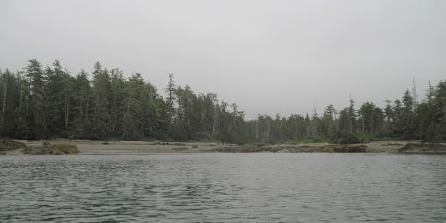
Banks Island: Northern
Tip
As noted in Wild Coast II, there are several fine sand west coast style beaches along the north shore.An issue with these flat beaches is that with the large range of tide levels, it can be several hundred meters from camp to water if you hit it at low tide.

The first 2 sites marked moving west from Deadman Inlet are flat sandy beaches
53˚37.671’N /
130˚28.385/W
Deadman Inlet The long shallow beach near the west entrance to Deadman Inlet has 2 small fresh water creeks that drain the upland bog behind the beach

Beach at
west side of Deadman Inlet(mid to high tide)
53˚37.900’N / 130˚31.240’W
For those who cringe at the
thought of fine sand in their sleeping bag there is a steeper gravel beach 1.2
nm west of Deadman Inlet at 53º 37.90 N , 130º 31.24W. It appears to be clear
to the lowest of tides and has a more substantial creek.
Gravel Beach West of Deadman Inlet


53° 36.735'N/130° 33.979'W
Larsen Island
We got through the channel between Larsen Island and Banks
Island with a foot or so to spare when the tide was about four meters at
Griffith Harbour. A boulder type beach is located on the outside of Larsen
Island; a limited sand strip provides access to the upland beach, with
potentially a few campsites. Outer islands and reefs provide protection from NW
winds and waves.

We did not investigate the heads of Norway Inlet and
Griffiths Harbour.

53° 33.671'N/130° 32.741'W
Solander Point
A tombolo on the south side of an inlet and just north of
Solander Point provides a very pretty stop and a potential campsite for a few
tents. There may be freshwater sources further up the inlet. Tombolo north of Solander Point.

53° 32.600'N / 130° 30.600'W
Sneath Islands
From Solander Point, staying in the lee of the Sneath
Islands, to a south facing bay 1 nm east of Laverock Pt. there are 3-4 sandy
campable beaches which appear capable of surviving all but the highest tides. The Sneaths provide exceptional protection to these beaches.
We were in this area when tide levels at Griffiths Harbour were near to 5
meters and commonly in the area in the lee of the Sneath Islands we could see a sandy bottom below us. What the beach Small protected
beaches conditions are in this area with low tides east of Sneath Islands
remains to be discovered by others.

East of the largest of the Sneath Islands is a nice sandy beach without water but which appears to be campable at all but the highest tides.

53˚32.130'N / 130˚29.510'W
A Southwest facing inlet entered along 53˚32'N has a strong creek at its head and could be used for camping but the bottom is shallow and at lower tides it might be many hundreds of meters from the tent to the water. There is a good and fairly well protected beach along the north shore of the inlet.

53° 29.410'N / 130° 25.730'W
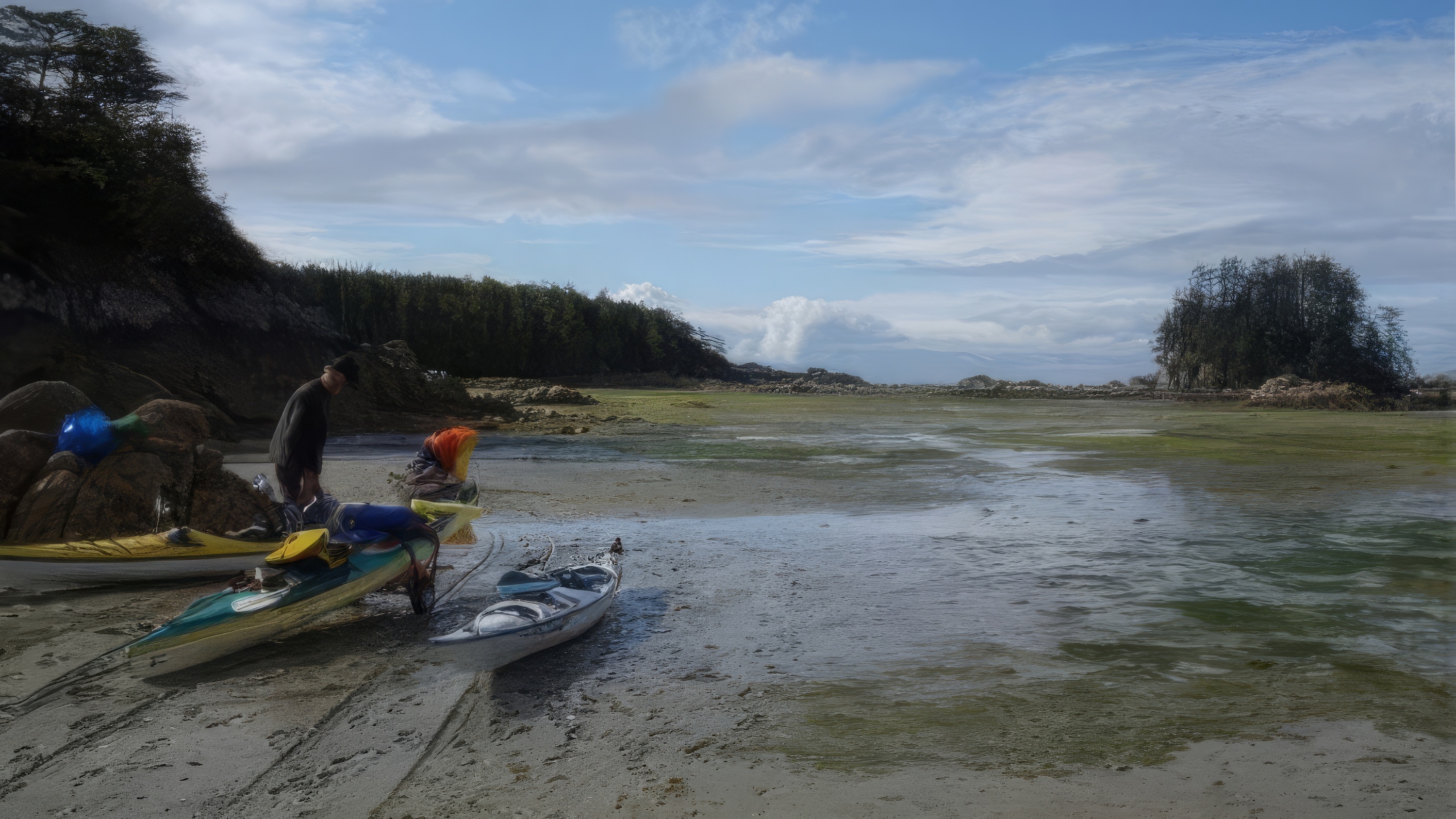
Kingkown Inlet / Kirkendale Island
This large inlet deserves to be explored. Regrettably, except for the western
islands, it was not for us to do. The
best place we found was on the southwest side of Kirkendale Island. The beach
is mainly gravel with mud toward the bottom but has firm footing along one side
at lower tides. There is room for 3 to 4 tents on the beach, and considerable
potential on what may be a midden in the upland. We survived camping on the beach with a 20.3
ft tide (at Griffiths Harbour) with low pressure and a south wind. The site is
well protected from southeast weather.

Kirkendale campsite looking out at low tide
There are good creeks on the Banks Island shore to the north
of Kirkendale; one is at the top of a pretty bay and lagoon at 53º
29.369’N/130º 25.766’W.
Tidal currents around these islands can be quite strong and should be taken
into consideration when visiting the area.

53°27.288'N / 130°23.684'W
Going south from Kingkown Inlet there is a south-facing bay. That is the last place of refuge before Kelp
Point. This good-sized bay is spanned
partway in by what may be a man-enhanced wall of rocks which create a large
inner bay. We stayed here due to
deteriorating sea state, and the central of the three beaches survived a 21'
tide at Griffiths Harbour. The beach is
sand/grit, a relatively short area of sand/boulders further down, and then a
very long sand/mud lower beach. If the
goal of the rock wall was to create a large clam bed, it worked. The site is accessible only with tides
greater than 11.5' at Griffith Harbour. There is a large creek to the south of
the campsite and an interesting tidal flat to the north.
Waiting for the tide, camp south of Kingkown Inlet.
From the previous site it is about 4.7 nm to Kelp Point
without opportunity for shelter. This is
the longest fully exposed section of Banks Island. With current against us, it took us about 2 ½
hours of steady paddling. A good
opportunity to pick up a coho.

53º 22.96'N / 130º 15.94'W
Kelp Point AKA Crap Camp
Approximately 1.7 nm east-southeast of Kelp Point is a
south facing bay entered along 130º 16'. Toward the head of this bay on the east shore
is a sand/grit/gravel relatively steep beach which is accessible down to about
4.5feet (Griffiths Harbour). The upper
beach is strewn with drift wood and logs some of which will need to be moved a
bit to make camping areas. We had no
difficulty clearing spots for four tents. Once into the drift wood, the beach easily
survived 21' at Griffiths Harbour. There
is freshwater a short paddle away. This
is by far the best site in this area that we found with the next good site
being around 12nm south.

Beach and campsite (with some log moving) 1.7 nm southeast of Kelp Point
We could find no suitable
site in the vicinity of Survey Bay. There is freshwater a short paddle away. This is by far the best site in this area
that we found with the next good site being around 12nm south. We could find no suitable site in the
vicinity of Survey Bay.

53° 20.790'N/130° 10.200'W (NAD27)
Wreck Islands
We spent quite a long day checking out the area proximate to the Wreck
Islands, Waller Bay and south as far as the larger bay entered along
approximately 53º 14.5'N with limited success in finding good stops and
campsites. There is a very small beach
patch of gravel above most tides which would be suitable for 2 or 3 tents (cozily
spaced) at the end of a narrow west facing cove proximate to 53º20.79'N and
130º 10.2'W (NAD 27). The top third of
the beach is gravel, the middle third rock/gravel and bottom third extremely soft
mud. This is the sort of place that one
would seldom choose as a goal but which could prove to be much appreciated, in
an area with few places to land or camp, in a situation where sea conditions
were deteriorating. Bring your mosquito
net and don’t expect to spend much time enjoying the view.

A refuge from deteriorating sea conditions
Going south there is a sand beach which is suitable for
taking a break at tides below 4.5 meters (at Griffiths Harbour) at 53º 17'N
130º 5.7'W. Above 4.5 meters is rock and
we found no place to camp. There is a
creek a little to the east.

53º 15.130'N / 130º 1.400'W
Grief Point
Approximately midway between Grief and Spearer
Points is a well protected bay entered along approximately 53º14.5'N. This bay is generally southwesterly facing and
there are some islands which divide it into westerly and easterly parts. North of the easterly part is south facing inlet
which at its head has a small river that drains several lakes shown on the
chart. The chart indicates a sand
bottom, which seems unlikely and it shows that the inlet dries which might
happen but for the flow of water from the small river. Near the head of this inlet along the north shore
you will find a small beach which is notable for the presence of an apple tree. There are remnants of a boat launching channel
with some cross beams for sliding a boat and near the high tide mark there are further
beams and other remnants of usage within the last 100 years or so. At high tides the beach disappears but in the
upland there is room for several tents on a flat area that possibly has a much
longer history than the more obvious recent use. At higher tides it is possible to paddle up
the river into the lake but show caution as at lower tides the route becomes a
water fall. We left at a fairly low tide
and launching into the river on sea weed was relatively easy.
We were very lucky to find this place which was shown to
us by the only people we met on the outside of Banks. A couple from Washington who have spent the
last thirteen summers in their sailboat checking this area out happened to have
an interest in archaeology and an intimate familiarity with the shoreline of
this bay. We never would have found this
place without being taken there personally and we found no other good site
between the Wreck Islands and Terror Point.
The place is a little easier to spot now since we cleared a few branches
to facilitate access to the upland and make some room for boats. At times of neap tides there would be room on
the beach to camp which has patches of gravel. There is a substantial creek with good water
at the top of the inlet.

Creek at Head of Inlet

Remnants of boat launch

Camp at head of inlet
There is a west facing bay entered along 53º 11'N which has a sand beach along its south shore. This is one of the few places that looks like a beach on Google, the problem being that it is only serviceable at medium to low tides and we found no place that would survive a higher tide.

53º 22.96'N / 130º 15.94'W
Terror Point
Terror Point is on an island marked ‘61' on chart 3984. Immediately NE of ‘61' is a small narrow
island approximately 1/2nm in length which is unnumbered. North of the northwesterly corner of this
island, on Banks Island, is a small sand/shell beach which is quite visible on
Google. We landed at a lower tide in the
channel behind the longer, narrow island entered from the east and it was a
couple of hundred meters to the beach over gravel/rocks/mud which provide quite
good footing. The tide marks on the
rocks suggest that parts of the beach would survive most tides although be aware
that the beach is backed by rock and there would be no place of retreat should
the tide keep coming in. A difficult
place to access except at higher tides but a possible choice, if one were going
from south to north and seas conditions past Terror Point were unsuitable. This beach would be exposed to wind from the
SW but it is protected from swell by the outer islands.

The Terror of Terror Point

53º 22.96'N / 130º 15.94'W
Calamity Bay
We found places in Calamity Bay where camping is possible along the west
and north shores but they are marginal and would require some clearing and
flattening. However, on one of the small
islands in the north east part of the Bay is the best site we found since
leaving the north end of Banks Island. At
approximately 129º 51'W between 53º 10.5' & 10.8' N there is a group of
four small islands. At lower tides the
islands are best accessed along the shore of Banks Island approaching from the
south. The east and north shores of the
most northerly and smallest of these islands has good beaches for landing. The north end of this small island has
excellent beach camping on gravel under some trees which should survive most
tides. This is a very pretty spot. Approximately 1/3 nm north of this small island
a creek enters from the NE which has a strong flow. Near where the creek enters the bay, there is
a beaver dam which creates a small lake - an excellent chance for a fresh water
swim.

Camp on small island in Calamity Bay
We did not check out the bays on the southeast corner of
Banks west of the campsite so there may be some opportunity to camp along the
north shore of Otter Passage.

No comments:
Post a Comment