
West Coast of Aristazabal, Price & Athlone Islands
Includes Rennison and Anderson Islands
A Field Guide for Paddlers
Why?
This guide is chapter 2 of an effort started in 2011 which sought to fill in
some gaps in the Wild Coast series of guides by John Kimantas.
The 2011 effort resulted in West Coast of Banks Island – A Field Guide for Paddlers. Like the Banks Island guide, areas covered in The
Wild Coast Volume II are not included in this chapter, except by reference.
Who?
In 2012 nine members of the Nanaimo Paddlers club decided to survey the western
shores of Aristazabal (including all of Rennison Island and Anderson Islands),
Price and Athlone Islands. It was a good
test for the campsites as eight tents needed to be accommodated. All members of the group contributed to the
gathering of information. Most of the
photographs were taken by Geoff Mumford and Karina Younk. Most of the pre-trip survey preparation and
post-trip organization of the information was done by Reale Emond and Glenn
Lewis.
Overview of the surveyed area
From Oswald Point on the northwest corner of Rennison Island to Cape Mark
southwest of Athlone Island is about 80nm going more or less directly. However, those wanting a shorter open water
crossing of Laredo Sound at the south end of Aristazabal and an alternative to
the 8-9 nm crossing of Milbanke Sound at the south end of Price will need to
paddle an additional 15-20 nm. The area
is isolated but not so remote or unoccupied as Banks Island. Sports fishers from the North King Lodge
located in Borrowman Bay on Aristazabal Island will be seen from the north end
of Aristazabal down at least as far as Clifford Bay. Similarly, the West Coast Resorts lodge near
Athlone Island spread their guests between Cape Swain and Cape Mark. In an area that is several hours away from the
life boat stationed in Bella Bella, the presence of sports fishers provides
some additional support should an emergency arise.
The survey area is uniformly quite flat and is largely part of a formation
known as the Milbanke Strandflat. This
means that shallow waters extend west of the main shore line. Between Cape Mark and Oswald Point there are
between 500-1000 islands or islets and perhaps twice that number of rocks and
reefs, mostly within a mile of the main islands. Most of the time, paddlers will be either
fully or partially protected from sea states farther to the west. Another benefit of the low topography is that
most of the clouds that will drop rain on the hills and mountains to the east
carry on by without stopping. Ocean
swell that was often substantially blocked by Haida Gwaii further to the north
becomes more noticeable as one moves south from Clifford Bay on Aristazabal.
We found the area relatively easy to paddle for a western exposure, mainly due
to the large stretches of inshore paddling available that were fully protected
and the relatively short exposures to the open ocean. Paddling the area does require open water
crossings of Laredo Channel (about 4.5 nm), Laredo Sound (about 6.5 nm from the
south end of Aristazabal over to Price going directly), Milbanke Sound (about 5
nm from Langford Cove on Price Island to Salal Island or 8-9 nm going directly
from the south end of Price Island to Athlone Island). Aside from the presence of sports fishers,
the area shows few signs of human use except for two cabins near the northern
end of Aristazabal and a whale observation post at Ulric Point. Weather information comes from the Klemtu
repeater in the northern sections and the Calvert Island repeater further
south; reception is generally quite good.
Weather
Aristazabal and Rennison Islands are in the southeast corner of the South Hecate weather reporting district. Often weather changes will come from the west along a front that tends northeast to southwest and the timing of the arrival of these changes is relatively easy given the many weather stations to the north and west. (See the Banks Island guide for greater detail on this point.) From the south end of Aristazabal down to Cape Mark is the very northern extremity of the Central Coast from McInnes Island to Pine Island district and what is happening around Price Island is often substantially different from what is happening near the entrance to Queen Charlotte Strait. We found the data from the South Hecate buoy (about 25 nm southwest from Kettle Inlet or 35 nm west of Rudolf Bay) to be quite useful in squaring variations between the forecasts for South Hecate and the Central Coast. The West Sea Otter buoy is also sometimes useful in determining where the weather was changing as one moved north from Queen Charlotte Strait.
As noted above, the large amount of offshore protection often means that rising weather has a much reduced effect on sea state. As at Banks Island, the absence of highland and steep walled inlets near the coast means that inflow/outflow winds are not an issue.
Currents, Tides and Boomers
Variation in tide levels moderates as one moves south down the B.C. Coast. A tide variation of 20 feet during spring tides at the north end of Banks Island becomes a variation of 16 feet at the north end of Aristazabal and 15 feet near Seaforth Channel. It is not clear to us exactly what effect this has on the coast currents along the outer shores. Wild Coast II notes that in Laredo Channel floods run for approximately eight hours and ebbs for four hours of the twelve-hour cycle. Something similar seems to happen on the west coast of Aristazabal, particularly in Beauchemin Channel. We think it was not an error that the British Admiralty charts called what are now the southern Anderson Islands, Rip Tide Islands. While crossing from the southern Anderson Islands toward Aristazabal we encountered strong flood currents that slowed our progress to a crawl. Farther south, currents are generally less of an issue, particularly in the ‘inside passage’ along the shore of Price Island. We understand from others that conditions in Laredo Sound can become quite difficult either from the ebb tide meeting incoming swell or from winds that originate farther north in Laredo Channel. The day we crossed was calm and serene. A suggestion is to cross early in the morning and plan for either a small tide change or a flood. Our experience was that the flood current was quite strong in Laredo Sound near Aristazabal. It became increasingly weaker as we crossed to Price. We also understand from others that ebb tides meeting incoming swell can create substantial unrest near the entrance to Milbanke Sound, and while this phenomena is not part of our experience, it does make sense.
For those staying in the lee of the many protective islands and reefs, boomers are generally not a large issue as much of the route can be done without exposure to swell. However, for those staying farther offshore, vigilance is required as rocks and reefs are uncountable and the charts are not much assistance in locating many of them.
Access
Road access to the survey area does not exist. B.C. Ferries provide regular service to Klemtu and Bella Bella which are the closest access points. It is about 20 nm from Klemtu to Wilby Point (a good spot to make a choice to either head north to Ulric Pt. or South to Weeteeam Bay or Higgins Passage). Klemtu has two choices for ferry passengers. The Queen of Chilliwack (Discovery Coast Passage) lands in the village of Klemtu and launching is possible nearby. The Northern Adventure (Inside Passage Port Hardy/Prince Rupert) stops at Klemtu, going north and south every second week at the new terminal a mile or two north of the village. Loading and launching is possible under the ferry ramp at the new terminal; it is not a perfect place and is considerably more easily done on a rising tide and at higher tide levels. From McLaughlin Bay it is about 21 nm to Cape Mark and about 24 nm to Langford Cove on the east coast of Price Island. At higher tides the landing immediately south of the McLaughlin terminal is quite decent, and it is serviceable at lower tides.
Charts
The charts for Rennison, Aristazabal and Price Islands are based on datum described as either unknown, or NAD 27 and are of a 1:77 k scale. Notes indicated that locations on Price might be out by 150 metres. Detail for these islands, particularly detail of the many islets, islands, reefs and rocks, is scant and often difficult to follow. There are some better scale charts for Clifford and Weeteeam Bays which we found useful. We also relied on printed copies of Google satellite photos which were usually substantially more helpful than the chart. For Price Island we relied entirely on enlarged Google satellite photos (2.5 nm per 11”x18” sheet) which we had marked with longs and lats, taken from a terrestrial map to very good effect. Using that level of detail we were able to transit the west coast of Price Island entirely within the protection of off-lying islands, rocks and reefs 90% of the time. The chart for Athlone Island is a 1:40 k with recent survey data.
Communication and Assistance
Cellular service works at Klemtu and around Shearwater and Bella Bella but, so far as we know, not otherwise. VHF radio reception of weather reports is generally quite acceptable so we assume that communication with Prince Rupert Coast Guard radio would be similar. There is a lifeboat station at Bella Bella which should be able to provide rescue service within about three hours to the northern end of Aristazabal and perhaps as quickly as one and one half hours to the Cape Mark area. Most likely a call for assistance would be responded to by someone from one of the fishing lodges at Borrowman Bay, if you were in the northern half of Aristazabal, or at St Johns Harbour, if you were near Athlone. When on the west coast of Price Island, help might be a bit slower in coming. While the area is not so isolated as the outer coast farther north, we remain of the view that paddlers should be prepared to get themselves safely ashore and secure without outside assistance in the expectation that help will come but might take a while.
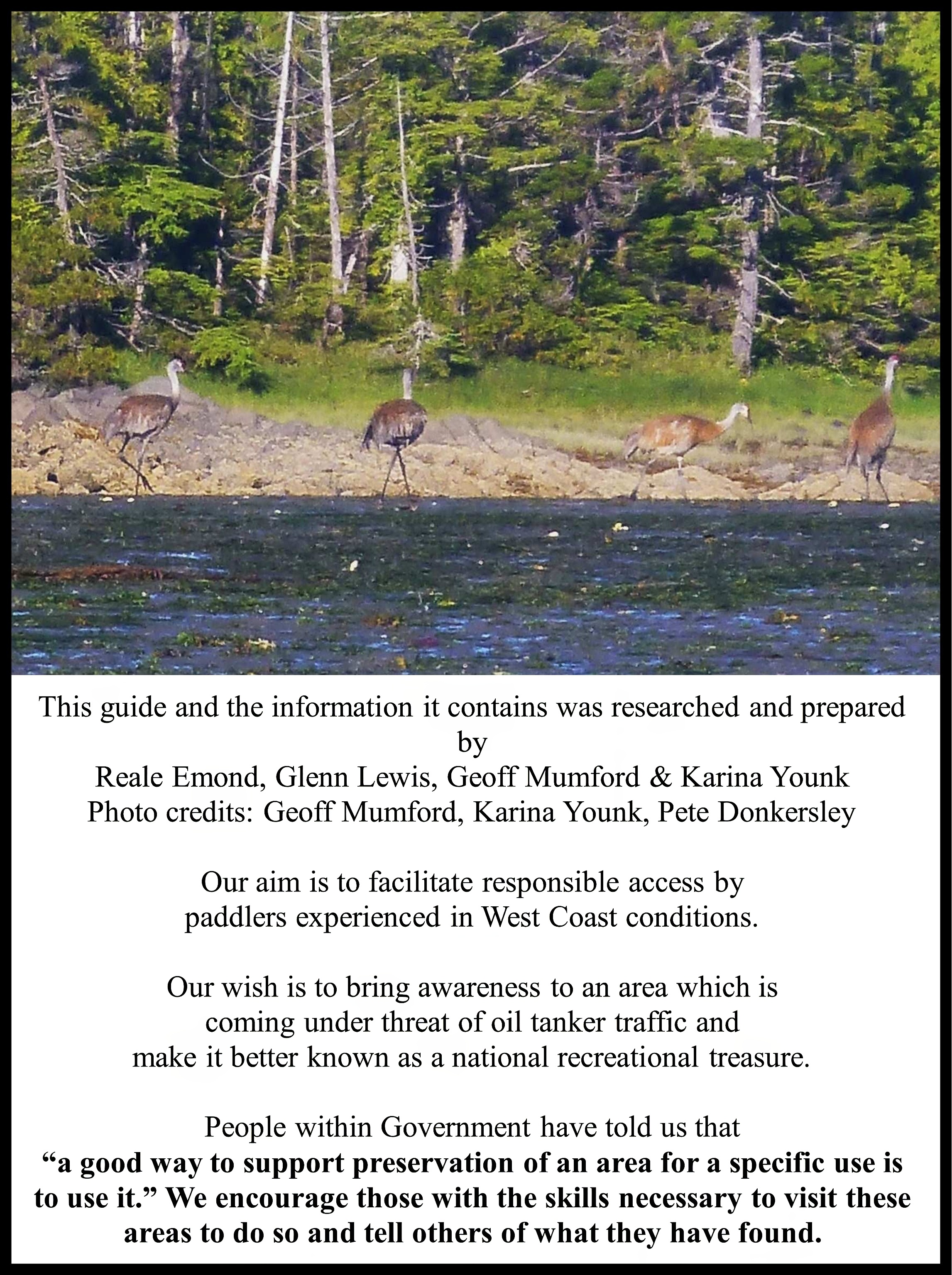
Terrestrial wildlife
As expected, wolves seem to be the dominant large species throughout the area although we did see some bear sign. The southwestern shore of Aristazabal was home to several groups of sandhill cranes which seemed to be using the place for their summer home. These large birds have a very distinctive call. For those interested in further reading, a recently published book by Ian McAllister, Following the Last of the Wild Wolves (2011) is a fascinating account of his experiences with wolves in the Central Coast written in non-scientific language. There is also a substantial body of scientific work on Central Coast wolves and their environment. A good place to start looking for this material might be the Rain Coast Conservation Society. Our experience is that not uncommonly in the morning you will notice wolf tracks around your camp that weren’t there the night before. Spending a bit of time trying to understand these animals and thinking about sharing their territory in a relatively benign way is, in our view, a good idea. McAllister says that wolves eat bears which probably accounts for the general lack of these animals where wolf packs are living.
Leave no trace
Except for the site on the more northerly Anderson Island (noted in Wild Coast II) and the Cape Mark site, you will find little sign of previous usage at resting or camping sites. There are signs of First Nations use and there is an Indian Reservation in the Weeteeam Bay area but no sign of recent occupation. Two of the sites we describe also contain what is left of campsites created and used by Kayak Bill (Bill Davidson) until his passing about 10 years ago. We hope that sites will be left the way they were found out of respect for those who came before and as a legacy for those who will come after.
Fishing
Our group ate fish when we wanted it (about 2/3 of the time) including several salmon and many ling cod and rock fish. One of our group fished for crab with what is best described as dogged determination. For the most part, the efforts were fruitless and we ate only one Dungeness. We also saw little sign of crabs although there are many areas where the bottom and shoreline would seem to be favourable. We saw no sea otters until we were in Queen’s Sound so they weren’t the reason for the want of crab. Shellfish are frequently available, but DFO has closed the whole area permanently as they apparently don’t test for PSP.
First Nations and Conservancies
There are no conservancies on Aristazabal Island and only a small Indian Reservation in the Weeteeam Bay area. The islands 5-10 nm west of Aristazabal are grouped into two conservancies and one Indian Reservation. The north end of Price Island is part of a conservancy and all of Athlone Island is part of the Outer Central Coast Islands Conservancy. The lack of Indian reservation lands in the survey area should not be taken as an indication that the area does not have a long and active history of First Nations use. More information about conservancies in the area is available on the B.C. government parks website.
The Survey
We had little definite information about camping opportunities on Rennison Island or the west coast of Aristazabal prior to our departure. Some of our group had paddled the west coast of Price and Athlone before so we at least had some confidence that we would find some place to camp in these areas. We had identified about 60 potential sites in the survey area from Google satellite images, which varied between so-so and quite good imagery (better than Banks Island). As is usually the case, many of the ‘beaches’ identified in the photos were large piles of logs. As with Banks Island, we did find good, or at least useable, camping sites at appropriate locations.
GPS points
Some have been taken from the chart or from Google satellite photographs and some were recorded at the various locations. We are satisfied the co-ordinates provided will get you close enough to each place that it will be obvious where to go. The main GPS we were using to record site locations quit and the information was not recoverable; accordingly we had to do as well as we could after returning. There is a lesson here for those who rely mainly on electronics.
Rennison Island and the Anderson
Islands
Although Rennison Island would probably be a side trip on
most paddlers’ itineraries, it is the first place to stop for those coming
directly from Campania Island, and the presence of a good site at the north end
of Rennison is a valuable asset. Those crossing Caamaño Sound should be alert
to the possibility of strong tidal currents which may have a significant impact
on crossing times.

52° 50.966'N/129°
20.428'W—r1
Along the north shore of Rennison Island, about ½ nm southeast of Oswald point
is a northeast-facing bay with an all-tide Westcoast sand beach. This is an
excellent stopping point for those coming from the north. We thought the
camping was better on the more easterly part of the beach. There is a good
creek in another northeasterly facing cove a little more than 1/2 nm to the
east. This is a well-protected beach where it needs to be.

Beach north end of Rennison Island
52° 50.468'N/129° 21.230'W—r2
On the west coast of Rennison Island, east of the island at
approximately 52º 50.5’ N is a west-facing bay with three coves coming off of
it. In the southeast portion of the bay is a west facing cove with three
westerly facing beaches. The most southeasterly (centre) of these beaches is a
granite cobble beach that is very protected. Shown in the right of the photo,
at the top of the beach there is room for 3 or 4 tents and potential in the
upland to create some flat tent sites.

Cove on the west coast of Rennison Island
52° 48.557'N/129° 21.807'W—r3
‘Karina Islets’
South of Rennison Island there is an island about 1/2 nm in length that is
marked ‘250’ on the chart. From the northwest corner of this island, an
archipelago of small islets extends about 1/2 nm toward the northwest. The more
northerly and westerly of these small islets form a northeast-facing shore.
Toward the centre of this shore is a small islet with a sand and rock beach
that is an exceptionally pretty site. There is camping on the sand and in the
upland. This site is somewhat exposed to offshore weather.

52˚47.332'N
/ 129˚21.118'W - an1
The site identified in Wild Coast II on the north
shore of the largest of the Anderson Islands is an excellent choice for this
area with an all tide beach. There is
room for 3 or 4 tents in the upland near to the cabin, and we were able to make
space for 4 more on the top of the beach which survived spring tides. The numerous Anderson islands and islets between
46’ and 47’ north are an interesting place to paddle and have some potential
for camping but at the risk of being stranded at lower tides.

52˚
45.044'N / 129˚ 22.510'W - an2
At 52º 45’ N, the Anderson Island marked ‘195’ has an
excellent sand beach at the west end of its north shore. With a 5.4 m tide the night before, there was
room for 3 or 4 tents on sand. The beach
has better sun exposure than the site on ‘180’, three miles to the north and is
similarly well protected from most winds. There is no upland development and with the
highest tides, camping would be difficult.

Sand beach on north shore of Anderson Island marked ‘195’
Aristazabal Island
The west coast of Aristazabal from Ulric Pt. to Kettle Inlet has mainly cobble beaches and generally poor camping opportunities. Our choices for the north end of Aristazabal would be one of the Rennison Island or Anderson Island sites.

52˚ 41.732'N / 129˚ 14.471'W
We found two sites proximate to Kettle Inlet which are both quite serviceable.
Along the south shore of the inlet, not far from the beginning of Aristazabal
Island, is a good, fairly steep beach that has a mixture of sand, gravel and
smaller cobble. We found room for 4 tents on sand with a 5.4 m tide and there
were other good single tent sites. Across the inlet is an excellent creek shown
on the chart. The problem with this site is that while launching at a .4 metre
tide was quite easy, we needed to paddle 1.5 nm west before we could turn south
as the string of islands that form the outer shore of Kettle inlet joined at
low tide.

52° 41.469'N/129° 14.391'W—a2
From the above site we were able to walk to a west-facing bay entered along
about 52º 41.5’. A site on the south shore about halfway into the bay has a
beach composition similar to the above site, good beach camping and better
upland potential than the site in Kettle Inlet. The access to this site appears
to be all tides through a small channel about 30 feet wide. The camping area is
well protected from NW winds.

52°
36.150'N/129° 10.400'W(NAD27) - a3
If you have chart 3710, enter from the north between Woodcock Islands marked
‘140’ and ‘100’ to a beach which is sand up to about 2.8 metres and then some
larger boulders before becoming a sand beach again. Camping would be possible
on sand at tides less than about 4.5 metres (Beauchemin Channel). Flux creek at
the head of Clifford Bay is a good source of water but the bay dries for a very
long way out at other than higher tides.

52° 35.100'N/129° 09.200'W(NAD27) - a4
The best site in the Clifford Bay area is on the northeast corner of an island
marked ‘145’ approximately .2 nm southeast of Babbage Island (marked ‘200’ on
the charts). This northeasterly facing
bay boasts a fine sand beach with good beach and upland camping. This site may have a long history of human
usage. The site is well protected from
most winds.
52° 33.540'N/129° 08.976'W—a5
From
Clifford Bay we made our way inside of the Normansell Islands, just, with about
2.6 m of water (Beauchemin Channel ). The
most southerly large Normansell island has a bay on its northeast corner with a
beach that is not too long at lower tides and is quite useable. There is camping for 4 or 5 tents on sand.

We found two good sites in Weeteeam Bay, both in the SE section.
52° 29.145'N/129° 00.517W—a6
On the west side of the largest island a little to the SE of Weeteeam Bay is a
fine sand beach that has the remains of a Bill Davidson (Kayak Bill) camp. This
beach is well protected from ocean swell but exposed to SE winds. There is
extensive beach camping and some opportunities above the high tide line—a very
pretty spot. This site would be the first choice for most people visiting this
area. About 1 nm north of this site a strong creek that is a good source of
water enters behind a small islet.


52° 29.479'N/129° 0.818'W—a7
There is a second northeasterly facing site approximately .3 nm to the NNW of this site on the island immediately across the channel. This secondary site is mainly sand interspersed with some rocks, but it is quite useable. It has good beach camping and some upland opportunities. The advantage of this site is that it is protected from SE winds and would be our choice if we were expecting to be spending some time in poor weather.

On the east coast of Aristazabal is an east-facing cove, immediately north of the long fingered cove shown on the chart, that is another Kayak Bill site. We had planned to stay at this site for an early morning start to cross over to Price Island. We found that the top of the beach was quite rocky and the areas that were sandy were covered with a very heavy load of drift wood, logs and flotsam. With not too much effort a few tent sites could have been cleared.


Price
Island
Our plan had us crossing directly from the Southeast corner
of Aristazabal over to the Clifford Bay area but poor camping at the site we
expected to stay at and flat seas with a flood tide saw us cross to the Higgins
Passage site instead. It turned out to
be a bit of good luck. On an early trip
down the west coast of Price we had tended to stay outside of the rocks and
reefs as suggested by John Kimantas, and there was little help from the chart
in navigating closer to shore. This
time, we abandoned the chart and relied instead on blow ups from Google Earth
satellite images which we overlaid with longs and lats. The result was surprising, in a very positive
way.
We found that it is quite possible to paddle about 90% of
the west coast of Price Island protected from swell and often wind. The route is a meander in the lee of hundreds
of islets and rocks, for us mostly on flat water. These conditions were not just good fortune
either as we were weathered ashore for a day at the campsite at approximately
52° 23’ N during which southerly winds in the 20-25 knots range had ample
opportunity to set up a following day of 2+ metre swells.
Price Island is, for me, the best place on the coast if you
like to meander among islets in a rugged and isolated place. The main challenge to the route is trying not
to get lost among the islets, many bays and coves. Even with photos with a scale of about 2.5 nm
per 17” sheet it was sometimes difficult not to get a bit confused, and we
found ourselves resorting to the GPS and comparing it to the lats and longs we
had marked on the photos.
Our suggestion is to plan your trip so that you will be
paddling during times when tide levels are quite high to take maximum advantage
of the most protected channels. The site
at the west entrance to Higgins Passage is described in Wild Coast II. A very
pretty site on what appears to be a very large midden.
For a break there is a nice small beach at 52° 25.198'N / 128°
46.012'W that is sandy and very sheltered. Camping opportunities on the beach would
disappear with higher tides and upland camping is possible but difficult.
Rudolf Bay has a marine trail site marked in Wild Coast II
and there is a beach in the southerly cove inside the bay that is very
protected. The beach is clay/sand and it
would be very long at low tides. Camping
would be possible on grass above the high tide line but expect to share your
site with more than a few bugs. Some
large animals appear to use the grassy areas for foraging. Not a site we would chose if carrying on a
little farther south were an option, but a very well protected place if one
were weathered ashore.
52° 23.270'N/128° 45.300'W—p1
Here is the best beach on the west coast of Price Island. It is easily identifiable on the Google
satellite images and offers plenty of room among the drift logs for camping at
all but the highest tides. We were there
for a day with strong southerly winds and significant swell on the ‘outside’
and our surf never got above about 6”. We
found our camp in the south corner of the beach to be very protected from the
wind. At the highest tides, immediately
south of the main beach is a small pocket of sand (behind a very small islet)
which would be suitable for camping at all summer levels. This pocket would be hard to land at but at
spring tides boats could be left on the logs on the main beach and gear easily
carried the short distance to the campsite.
Alternatively, the lee side of the islet has a couple of spots in the
grass and gravel.

Paddling in the lee of the islands south of this site
between 52° 22-23’ is possible only at higher tides but it is an interesting
maze if you have the time and water levels are useful.
The campsite just described is the best
one on the west coast of Price Island, but it would be better if it were about
5 nm farther south. To get from here to
somewhere other than Price Island, two of the choices are to cross from Day
Point over to Athlone Island, a distance of 8+ miles of open water, or paddle
part way up the east coast of Price and cross a shorter, more protected, route
to Salal Island. Both would benefit from
a starting campsite toward the south end of Price. On an earlier trip we had spent quite a lot
of time checking out the southwest shore of Price below 52° 19’ and found no
good place for a group. We ended up in
Muir Cove at a place that is remarkable as the worst camp site I have endured
on our coast. We have two suggestions
and one place that we didn’t check which might work:
52º
18.978'N 128º 43.576'W—p2
At approximately 52º 19.1 N 128º43.7 W is the entrance to a
northwesterly facing cove that we found to be without swell. At the head of
this cove the beach is sand below about ½ tide and cobble and boulders above
that level. There is a weak creek toward the more northerly side of the head of
the bay and beside the creek a tree where you will find room for a couple of
tents on grass. There are other similar spots a little to the south of the
creek which would also be quite useable. Tent sites appeared to be above summer
highs and this site would be a preferable choice to Cove protected from swell
on west coast of Price Island Langford cove at spring tides. It is not the most
scenic site on this coast but it is in the right place.

52º 17.127'N 128º 41.143'W—p3
Near the west entrance to the channel between Day Island and Price Island is a
SE facing cove located at 52º 17.127’ N 128º 41.143 W which may have a beach
and possibly a place to camp. We did not check this spot out as we hadn’t
identified it as part of our survey, but one of our group thought that it might
be okay and some people we spoke to after returning were also aware of this
cove as a possibility. This is not the sort of place a paddler would want to
rely on, given the general inhospitality of this shore, but if you are passing
by it might be worth taking a look at.
52º 20.149'N 128º 37.502'W—p4
We stayed at the head of the south arm of Langford Cove where we found a beach
that was sand below about ½ tide and then cobble and boulders with areas of
gravel above that. The beach was fairly flat and it was not difficult to manage
the boats. There is plenty of room on the beach at this site at times of neaps
but at spring tides most, if not all, of the beach would disappear and camping
in the upland would only be a choice with considerable effort.
If you are crossing Milbanke Sound from here and like to fish, we caught a
couple of salmon near to Boulder Head.

Beach at the south arm of Langford Cove
Athlone
Island
In 2012, there was only one lodge in the St. John Harbour
area and it was located on the east side of Wurtele Island in Louisa Cove.
Expect to find sport fishers from the lodge spread out between Cape Swain and
Cape Mark. We failed to determine how much water is needed to get through the
narrows between Wurtele and Athlone Island, but we think that transit is
possible except at very low tides.

The marine trail site marked in Wild Coast II at the entrance to Yaaklele Lagoon is an excellent well-protected site. There is a small cove a little to the west that looks like it might be the site but beware as it dries and could leave a paddler stranded. The beach a little farther east offers a good gravel/sand all-tide beach with good beach camping and opportunity in the upland for several tents with little effort needed to clear some sites. A nice place to stop for a while, even if you don’t intend to camp.

In Dryer Cove, immediately south of Islet ‘40’ is a northeast-facing cove with a very nice beach and good camping. Since the fishing lodges have left Dryer Cove this has become, once again, a wilderness site isolated from the bustle from the lodge on Wurtele Island.

Wurtele
Island
Near to the south end of Wurtele Island at approximately 52º 10.4’ is a west-facing bay that has the look of a shore fully exposed to the open ocean. However if the tides are right and you are looking for a small gem on the edge of the world, this might be the place. If you enter the bay and follow close to the north shore you will pass some rocks and then a small peninsula that juts SW from Wurtele Island. Immediately east of the peninsula is a small islet, barely noticeable on the chart. On the east side of this islet is a small sand beach. Except at the highest tides, this beach is accessible only from the SW and not from the south. Even the route described might be unavailable at low tides. We were there when there was about 2.6 m of water (using the Gosling Island tides) and landing was on boulders which was made easy by the gentle slope to the beach and absence of swell. The sand would not be accessible until the tide was about 3.5 metres. This is a site that would be most useable if your timing allowed coming and going at relatively high tides.

Wurtele Island site
52º 09.132'N 128º 31.826'W—cm1
The campsite at Cape Mark, noted as a marine trail site in Wild Coast II, is
one of the few sites in this area with established upland camping. It is located on the NE corner of Island
‘35’. Access from the north is possible
only at higher tides and even then at the risk of a very long carry to the main
beach. The better choice for access is
to paddle south between ‘35’ and’46’ and enter via a small channel from the
SE. This is a large sand/gravel beach
with developed upland sites. A
difficulty with this site is that at tides below about half, the carry north
would be daunting and even the channel to the SE becomes very rough with
boulders.

We hope that making this information available will not only
facilitate the journey for others, but also bring some awareness to a large and
exceptionally beautiful part of our remote coast. An area that would take a
very long time to recover from misuse or environmental degradation.
No comments:
Post a Comment